On October 24th 2017 I published a piece here about the etymology of the townland placename Ahalin (Aughalin) in Knockaderry in West Limerick. You can catch up on the original article here. In it, I focused particularly on the local lore and folk wisdom which still holds that the placename Ahalin (Aughalin) is translated as Acadh Lín (the field of the flax). I was able to trace the fact that this translation came about largely through the teaching and forceful personality of the local Principal teacher in Aughalin National School, Michéal de Burca in the 1930s. In fact, with very little encouragement, local people could tell me that Ahalin meant ‘the field of the flax’ and most were also able to pinpoint its location.
Today there are two English variations of the placename, the more official Aughalin, which appears on the Ordnance Survey maps and the townland has also been referred to as Ahalin since at least 1831 when it appears on the Census Returns.[1] In 1867 a weighty limestone plaque was erected on the new National School recently opened in the area – this read ‘Ahalin National School 1867’. This plaque can still be viewed today embedded in the wall of the newly constructed set-down area and parking lot in the new school in Ahalin.
There is very little problem with the English versions of the townland’s name and both (Aughalin and Ahalin) are accepted locally and are often interchangeable. What is problematic is the current official Irish translation (or re-translation) of the placename being used by the Placenames Commission. P. W. Joyce in the second of his three-volume work on the origin and history of Irish names and places, first published in 1875, tells us that, ‘In the parish of Clonelty, near Newcastle in Limerick, there is a townland taking its name from a ford called Aughalin, the ford (ath) of the lin or pool’ (Joyce, 409). In the Preface to Volume One, Joyce, a learned Limerick man from Ballyorgan, acknowledges the help received from another placenames expert, Dr John O’Donovon, when he says, ‘I have had the advantage of two safe guides, Dr John O’Donovan and the Rev William Reeves, D.D.’ (Joyce, Vol I. vii). John O’Donovan, of whom more anon, visited the parish of Clonelty, present-day Knockaderry, in July 1840 to carry out a survey as part of the original Ordnance Survey mapping exercise carried out in Ireland. He also mentions Aughalin and gives its meaning as ‘the ford of the pond or pool’. This is the obvious literal translation, ‘Áth’ being the Irish for a ford and ‘Linn’ being the Irish for a pool. (Dublin was once Dubh Linn or Blackpool!).
Amazinly, in spite of this information and scholarship and also local knowledge and traditional usage, the official Irish version of the townland is given as Áith Liní in the Placenames (Co. Limerick) Order 2003. In Irish ‘Áith’ means ‘a kiln’ and there is evidence from old maps of the area that there were at least two kilns in the area. However, if we accept that the present anglicised form of the townland, Aughalin, refers to Áith meaning kiln there is still the difficulty that ‘Liní’ has no obvious meaning and no known local connotations or associations.
Surely local lore must count for something in trying to hear the faint whispers of a once rich oral tradition from the past. Gerard Curtin deals with this in the Introduction to Every Field Had a Name when he says:
The survival of hundreds of minor place-names in the south-west County Limerick, in an area that remained Irish speaking for longer than many other areas of the county, shows the extraordinary richness of the topoynmical tradition in Irish.[2]
According to local knowledge and tradition (more than likely promoted by Michéal de Burca who taught and lived in Aughalin from the 1930s until the 1960s), the correct rendering in Irish of the anglicised word Ahalin (or Aughalin) is Achadh Lín which he translated as ‘the field of the flax’. This is the Irish version used locally to this day and the ‘new’ Primary School in Ahalin (opened in October 1963) is known as Scoil Mhuire, Achadh Lín.
My original blog post also tried to research the link between the locality and the growing and milling of flax and found that there was a history of flax growing in the locality and that as far back as 1654 the Limerick Civil Survey records a tuck mill[3] for flax (and later for grain up to 1924) in Ballinoe. This mill was known as Reeves’s Mill. This, in turn, led me to consider other possibilities as to the etymology of the place name and to research the existence of the placename over the centuries. Art Ó Maolfabhail takes such a longer view in his seminal research, Logainmneacha na hÉireann, Imleabhar I: Contae Luimní, where he outlines the etymology of the placename Áith Liní as it has appeared in various documents and other official sources down the years:
- 1586 it appears as Athlyne in Peyton’s Survey, p. 108
- 1592 it appears as Allyneghe in F5781
- 1655 it appears as Athliny in the Limerick Civil Survey IV, 256, and as Athlinye in the Limerick Civil Survey, 298.[4]
- 1659 it appears as Aheliny in Census of Ireland, c. 1659, 280.[5]
- 1715 it appears as Athlinny in Clarann na Gníomhas. 16.311.7576
- 1750 it appears as Aghelinie in Clarann na Gníomhas. 144.378.97897 and again as Aghelinnie in Clarann na Gníomhas. 144.379.97899
- 1761 it appears as Agaliny in Clarann na Gníomhas. 212.591.140955
- 1807 it appears as Agalinny or Aghalinagh in Clarann na Gníomhas. 603.137.410629
- 1840 it appears as Aughalin in O’Donovan’s Field Name Books and áth a linne in pencil in O’Donovan’s Field Name Books.[6] This is the anglicised form which is most commonly seen in the old Ordnance Survey maps of the 19th Century.
In light of other evidence, however, Ó Maolfabhail’s conclusion is disappointing. Having weighed all the evidence, he rejects ‘the ford of the pool’ version favoured by P. W. Joyce and O’Donovan and doesn’t even consider Michéal de Burca’s ‘field of the flax’ version. Instead, he concludes that the official place name translation should be ‘kiln of (unknown)’. He further adds: ‘Ní léir cad dó a sheasann Liní. Toisc gan abhainn a bheith san áit, measadh gurbh oiriúnaí áith (meaning kiln) ná áth (meaning ford)’.
Dr John O’Donovan, noted historian and the translator of the Annals of the Four Masters, an Irish-speaking scholar and scribe, was the Ordnance Survey’s overall Names Expert used by the Ordnance Survey during their survey conducted between 1824 and 1846. It was O’Donovan’s responsibility to enter all the Irish versions of names into the Names Books, in addition to the English spelling recommended for the published maps. For this reason, the Ordnance Survey of Ireland Names Books are sometimes referred to as O’Donovan’s Name Books. O’Donovan spent July and August 1840 in Limerick and he signed off on his work on the parish of Clonelty on 25 July 1840. He was assisted in his work in Limerick by Padraig Ó Caoimh and Antaine Ó Comhraí.[7] Ó Maolfabhail recognises the validity and status of O’Donovan’s work when he acknowledges that by 1840 there were only four other counties to be completed as part of this nationwide survey and therefore O’Donovan had the advantage gained from having completed twenty-five other counties. This experience stood him in good stead in trying to make sense of the etymology of the various placenames (Ó Maolfabhail, xvii).
One of the most important functions of the Ordnance Survey was to name the geographical features, prominent buildings and landmarks of each townland so that these could be included on the Ordnance Survey Maps when they were eventually published. We know from these Name Books that John O’Donovan visited and wrote up the account describing the antiquities and topographical features of the then parishes of Clonelty and Clouncagh in July 1840.
Information for each townland was collected and written into the Name Book under five headings: the received name, the name finally adopted for the townland and the one placed onto the 6-inch Ordnance Survey Map in 1837. The Name Book also provided the Irish form of the name and in many instances what the Irish form of the townlands’ names meant. This was the last stage of the ‘Topographical’ process. The orthography section of the Names Books provides the various spellings for each townland or place and the authority section gives the source from which these variations were derived. This was a controversial part of the Survey, especially in the Irish-speaking areas of Ireland. Thomas Larcom, the head of the Ordnance Survey, and, John O’Donovan, had a clear policy when it came to the variant spellings and meanings of Irish place-names, which was to adopt ‘the version which came closest to the original Irish form of the name’. Thus, it seems, for O’Donovan the presence or absence of topographical features like ponds or pools made little difference to him when settling on a particular name. What mattered to him was to settle on an acceptable form which remained faithful to the original in Irish.
O’Donovan‘s observations on the townland of Aughalin are to be found in these Name Books and a transcribed version can be accessed in the Field Name Books of the County and City of Limerick. It is a collection of more than 1,700 pages of transcribed notes by surveyors during the first Ordnance Survey of County Limerick, c.1840.[8] O’Donovan’s entry for Aughalin is as follows:
Aughalin, Áth a linne, ford of the pond or pool.
Aughalin – is his favoured anglicised version for the townland
-Version found in Tithe Book of Revd. J.Croker
-Version used by Revd. J. Cullinan, P.P.
Ahalin – Version found in Barony Book 1834
-Version found in County Presentment Book 1839
-Also found in Census Return 1831
Ahalina – as in Barony Map
Athliny – as found in Limerick Civil Survey 1654 – 56
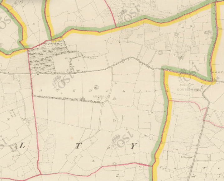
In the northeast part of the parish, a quarter of a mile east of Knockaderry Village. It is bounded on the north by Ballybrown townland and the parish of Rathkeale; east by the parish of Cloncagh; south by Kilgolban townland; and west by the townland of Kiltanna. It contains 565 acres, statute measure.
This townland is the property of Robert Featherston, Esq., and has a few portions of heathy pasture in the south and south west extremity. The remainder of the townland is under tillage and pasture. Aughalin Wood is on its north west boundary, and the road from Knockaderry to Ballingarry passes south of this wood through the townland. There are also three ancient forts in the townland, one of which is on its southern boundary. Acreable rent – £1 7s.
It has to be said that O’Donovan is being very diplomatic and circumspect here. The area he refers to as being ‘heathy pasture‘ is, in fact, a large saucer-shaped marshy area known locally as The Rhootachs. Aengus Ó Fionnagáin, lecturer in Irish at the University of Limerick and a noted placenames scholar suggests that the local name given to this area of marshy land could derive from the Irish word ‘ruaiteach’ meaning ‘reddish land’. It is interesting also that O’Donovan makes mention of Aughalin Wood as being another significant topographical feature of the townland. This was a large oak wood and probably where the present-day parish of Knockaderry gets its name – Cnoc an Doire, the hill of the oak (wood).
Another local historian and writer, Gerard Curtin, in his excellent book, Every Field Had a Name – The Place-Names of West Limerick while agreeing with Ó Maolfabhail’s assessment seems to give equal credence to O’Donovan’s translation:
AUGHALIN, Áith Liní, ‘the kiln of (unknown)’ according to Ó Maolfabhail, while O’Donovan (in Field Name Books, p. 440) believed it was from Áth na Linne, ‘ford of the pool’ (Curtin, 71).
Interestingly, Curtin also mentions that the most striking feature of the landscape in Aughalin up to the present day is the marshy area in the southwest of the townland known as The Rhootachs (also Ruatach or Rhootaigh). This is the area which O’Donavon refers to as ‘a few portions of heathy pasture in the south and south-west extremity’. This covered over fifty acres c.1913.
I sent a copy of my original blog post to the Placenames Commission for their views and shortly afterwards received a reply from Dr Conchubhar Ó Crualaoich and in the reply, the popular belief that the townland name, Aughalin/Ahalin derives from ‘the field of the flax’ is totally debunked. He states:
In regard to Aughalin, I refer you to the publication Logainmneacha na hÉireann, Imleabhar I: Contae Luimní, ed. Art Ó Maolfabhail. In that publication one finds a number of historical forms of this place-name such as ‘Athliny’, ‘Aheliny’, ‘Athlinny’, ‘Aghelinie’, and a local version recorded in 1840 namely ‘áth a linne’, which are all incompatible with derivation of the final element from lín ‘of flax’, as that lacks a final vowel. The absence of a final vowel from the later official anglicised form, Aughalin and the variant Ahalin, is doubtless due to the common loss of unstressed final vowels in anglicisation (see Townlands of Wexford ). It is also noteworthy that the historical forms and the local spoken form do not reflect the long vowel in lín. Therefore, Achadh Lín cannot be the precursor to Aughalin in this instance – it is not at one with the overall historical evidence for this place-name.[9]
However, while this historical evidence certainly rules out a final lín ‘of flax’ in the Irish precursor, identity of the final element remains somewhat unclear, although it does reflect Liní, or similar, and it is for this reason, I believe, that the phonetic approximation Liní was recommended in the official Irish form of the name.[10]
However, he also puts forward an alternative theory. He says that more evidence has come to light that the surname Lyn is recorded among the Anglo-Normans in Limerick in 1374. According to Dr Ó Crualaoich:
This could have generated an Irish version such as An Lineach (gen. an Linigh) “the person called Lin < Lyn”- which in turn could be in the precursor to Aughalin, as in Áith an Linigh ‘the kiln of the person called An Lineach (< Lyn)’.
Áith ‘kiln’ is reflected in early historical forms of the name such as ‘Athlyne’ and ‘Athlini’, as áth ‘ford’ is unlikely given the absence of any river of size here.
In this regard, the presence of disused lime-kilns in this townland is notable (see Ordnance Survey 25” map).[11]
While I have not come across any evidence that a family called Lyn ever lived in the area there is the possibility that Lyn could be related to the Gaelic surname Fhloinn (Flynn) – a name common in the area until recently.
Either way, Dr. Conchubhair O Crualaoich’s final conclusion leaves little doubt – in his mind at least – that Ahalin (Aughalin) has not derived from an association with flax:
It can only be restated that the historical evidence for this place-name does not support derivation from Achadh an Lín. The word líon (gen. lín) is reflected in the evidence for a number of place-names, but this is certainly not one of them.[12]
So, it seems that the presently widely accepted local re-translation of Aughalin as ‘The field of the flax’ is just fortuitous because the memory of flax growing in the locality in the 19th century was still somewhat fresh in the collective memory in the 1930s. P. W. Joyce in Volume One of his magnum opus, The Origins and History of Irish Names and Places warns against using recent developments to explain an age-old placename:
It is very dangerous to depend on the etymologies of the people, who are full of imagination and will often quite distort a word to meet some fanciful derivation; or they will account for a name by some silly story obviously of recent invention, and so far as the origin of the name is concerned, not worth a moment’s consideration (Joyce, Vol I, p.5).
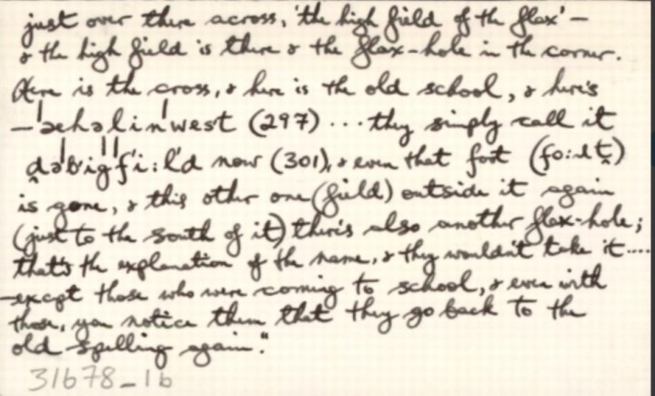
When Michéal de Búrca began teaching in Aughalin in the 1930s he used his extensive knowledge of Irish to make the rather tenuous connection with flax. However, we can now say with 20/20 hindsight that he was in error and this was but a modern example of revisionism or the shoehorning of the translation of a placename to appease the zeitgeist of the 1930s and 40s. In 1938 Michéal de Búrca helped coordinate the school’s contribution to the Duchas Schools Collection which was taken up in over 5,000 National Schools during that year. There are very interesting stories and ‘tall tales’ recounted in its pages and it is interesting to note that de Búrca, to add further complications, names the school as Áth an Lín (translated as the ford of the flax). However, in a way, whatever the Placenames Commission may think, his efforts to translate Aughalin or Ahalin, as Acadh Lín or Áth an Lín, are far more evocative than the meaningless Áith Liní, ‘the kiln of (unknown)’ proposed by Ó Maolfabhail and now held up as the ‘official’ version by the Placenames Commission and in the Placenames (Co. Limerick) Order 2003.
We already noted that Aughalin was first recorded in the sixteenth century in Peyton’s Survey of 1586 as ‘Athlyne’ (probably from the Irish Áth Linn, ‘ford of the pool’). There is also no doubt the landscape has changed considerably in the intervening 400 years. The problems which have arisen with the present Irish versions of Aughalin seem to be that a once prominent topographical feature of the landscape – namely a pond or pool – seems to have disappeared or even dried up. Gerard Curtin is of the opinion that as the landscape began to be enclosed from the early eighteenth century great improvements to the land by drainage took place over the following 200 years. We can see in the 25-inch Ordnance Survey Map of 1888-1913 that the fields to the north of this marshy area known as the Rhootachs (or Rhootiagh) are very uniform in size, suggesting planned reclamation. The original 6” map of 1843 also clearly shows what seems to have been an L-shaped screen of trees planted probably with a view to aiding drainage in the area. With this drainage on the periphery of the marsh, the level of water fell over many years. It is more than likely that in the medieval period this marshy area may have contained a body of water, such as a pool or a small lake or pond, particularly at very wet times of the year. The same map shows a crossing/trackway running from northeast to southwest through the marsh enclosed by ditches and is wide enough to drive cattle. O’Donovan would definitely have seen more evidence of this pool or wetland in 1840 than would have been in evidence in the 1930s when Michéal de Burca cast great doubt on the translation of Aughalin as ‘the ford of the pool’ because in his view, ‘there isn’t a pool within miles of this place, and there’s no ford in the place because there’s no river’.[13] In fact, the old Ordnance survey maps indicate a tributary of the Abha na Scáth river rises in The Rhootiagh. More recent maps show that the watercourse begins further to the north, a little south of the Knockaderry to Ballingarry road. This land in question is still known locally as The Rootach and is still very marshy and is presently under extensive forestry plantation. Curtin’s strong belief is that there was a ford through The Rootach from the medieval period, and thus the name, ‘the ford of the pool’ was given to the townland as a whole.[14]

There are, therefore, a number of plausible translations for the placename Aughalin/Ahalin since it was first mentioned in the sixteenth century. We must remember that all these variations were but phonetic representations in English of the Irish placenames then in use. Despite the lack of standardisation down the centuries, two elements remain constant – one is the ‘áth’ and the other is ‘linn’, or similar variations such as ‘liny’, or ‘linnie’. Ironically, the official version in use today is probably the most implausible one of all. Ó Maolfabhail’s safe translation is ‘Áith Liní’ which he translates as ‘the kiln of (someone unknown)’. Likewise, Michéal de Burca’s version of ‘Acadh Lín’ which he translates as ‘The field of the flax’, although still favoured today by locals, is probably stretching the language to breaking point as can be seen from Dr Ó Crualaoich’s assessment.
O’Donovan’s translation (ford of the pond or pool) deserves to be taken seriously because he, at least, visited the area and drew up a report on the antiquities, local history and topography of the parishes of Clonelty and Clouncagh as part of the Ordnance Survey team which undertook the mapping of the area in 1840.[15] It needs to be repeated that John O’Donovan, had a clear policy when it came to the variant spellings and meanings of Irish place-names, and that was to adopt ‘the version which came closest to the original Irish form of the name’. If we follow this logic then we no longer need to focus merely on topographical features and it doesn’t really matter if there is no pond or pool to be seen in the landscape today or even at the time O’Donovan visited the area.
The question, therefore, to be considered is was there a time in the dim and distant past when there was a pond or pool in Aughalin? Michéal de Burca cast doubt on O’Donovan’s and Joyce’s versions because, ‘there isn’t a pool within miles of this place, and there’s no ford in the place because there’s no river’.[16] Ó Maolfabhail follows the same line of argument when he settled on Áith meaning ‘kiln’ instead of Áth meaning ford when he says: ‘Toisc gan abhainn a bheith san áit, measadh gurbh oiriúnaí áith (meaning kiln) ná áth (meaning ford)’ (Ó Maolfabhail, p2). I have mentioned the presence in the old Ordnance Survey maps of a minor tributary of the Abha na Scáth river but really it was little more than a run off stream. However, as Curtin points out there could have been a pond or pool in the area of the Rootach in the past with a causeway or path(s) through it and all this has now disappeared because of land reclamation works and drainage over the centuries.
Therefore, there are no easy answers to our difficulty with the etymology of the placename, Aughalin. The different variations and permutations considered here will definitely not please the local people of the area who for the past three-quarters of a century at least have always translated Aughalin as Acadh Lín (The Field of the Flax). The reason I undertook this investigation in the first place was that I was unhappy with the official Irish translation given on the Logainm.ie website and the Placenames (Co. Limerick) Order 2003 where the townland of Ahalin is given as Aughalin and the official Irish version of the townland is given as Áith Liní. The big mystery for me is how did Ó Maolfabhail totally disregard the findings of such an eminent authority as Dr John O’Donovan in arriving at his final conclusion?
Hopefully, the original meaning of Aughalin/Ahalin, going all the way back to its first mention in Peyton’s Survey of 1586, has not been forever lost in translation! Hopefully, also, to misquote the eminent P.W. Joyce, this present ‘etymology of the people’ is worth more than ‘a moment’s consideration’……
Works Cited
Curtin, Gerard. Every Field Had a Name – The Place-Names of West Limerick. Sliabh Luachra Historical Society, 2012.
Joyce, P.W., The Origin and History of Irish Names and Places. Vol I. London: Longmans, Green and Co. Dublin: M.H. Gill and Son. First Published 1869.
Joyce, P.W., The Origin and History of Irish Names and Places. Vol II. London: Longmans, Green and Co. Dublin: The Talbot Press. First Published 1875.
O’Donovan, John. Field Name Books.
Art Ó Maolfabhail, Logainmneacha na hÉireann Imleabhair: 1 Contae Luimnigh, (Baile Átha Cliath, 1990).
“Ordnance Survey Ireland (OSi) 19th Century Historical Maps,” held by Ordnance Survey Ireland. © Public domain. Digital content: © Ordnance Survey Ireland, published by UCD Library, University College Dublin <http://digital.ucd.ie/view/ucdlib:40377>
Footnotes
[1] O’Donovan’s Field Name Books – http://www.limerickcity.ie/Library/LocalStudies/FieldNameBooksofLimerick/ – the information for the Parish of Clonelty is to be found at No. 36 CLONELTY.
[2] In County Limerick in the 1851 Census the baronies of the south-west, Connello Upper and Glenquin had the most number of Irish speakers, 59.4% and 58.2% respectively. See Breandán Ó Madagáin, An Ghaeilge i Luimneach, 1700 – 1900, (Baile Átha Cliath, 1974) (Curtin, 1).
[3] A tuck mill was used in the woollen industry to improve the quality of the woven fabric by repeatedly combing it, producing a warm worsted fabric.
[4] The Limerick Civil Survey IV, County Limerick (ed. Simington, 1938)
[5] Census of Ireland, c. 1659 (ed. Pender, 1939).
[6] Ó Maolfabhail, xvii, ‘leagan Gaeilge de logainm agus é scriofa le peann luaidhe, foirm gharbh é seo a breacadh síos go direach ó bhéal cainteora Ghaeilge’.
[7] Ó Maolfabhail, xvii
[8] The Field Name Books of Limerick can be accessed here: http://www.limerickcity.ie/Library/LocalStudies/FieldNameBooksofLimerick/ – the information for the Parish of Clonelty is to be found at No. 36 CLONELTY.
[9] Opinion of Dr Conchubhar Ó Crualaoich, Irish Placenames Commission via email correspondence.
[10] Opinion of Dr Conchubhar Ó Crualaoich, Irish Placenames Commission via email correspondence.
[11] Ibid.
[12] Ibid.
[13] Michéal de Burca in correspondence with the Placenames Commission – can be seen at https://www.logainm.ie/en/31678?s=aughalin – Check Archival Records for Aughalin.
[14] Opinion of Gerard Curtin via email correspondence
[15] O’Donovan’s Ordnance Survey Letters, Limerick, Vol 1 – his report on Clonelty and Clouncagh Church ruins is signed and dated 25th July 1840 – the letters can be viewed online at www.askaboutireland.ie and also on The Royal Irish Academy website.
[16] In correspondence with the Placenames Commission – can be seen at https://www.logainm.ie/en/31678?s=aughalin – Check Archival Records for Aughalin.


You must be logged in to post a comment.