
I live in a beautiful area of West Limerick and next door is the townland of Ahalin (or Aughalin). The townland has been referred to in English as Ahalin since at least 1867 when a weighty limestone plaque was erected on the new National School recently opened in the area – this read ‘Ahalin National School 1867’. The retranslation of this placename (Ahalin) into Irish has caused debate for decades. The famous Limerick academic P.W. Joyce in his seminal work, The Origin and History of Irish Placenames published in 1910 by M.H. Gill and Son, has it as ‘the ford of the pool’ and this indeed is one literal translation, ‘Áth’ being the Irish for a ford over a river or stream and ‘Linn’ being the Irish for a pool. (Dublin was once Dubh Linn or Blackpool!). However, as former local headmaster, Michéal de Búrca pointed out to anyone who would listen, ‘there isn’t a pool within miles of this place, and there’s no ford in the place because there’s no river’.

As you can see above the eponymous Master Burke goes on to give further information regarding the etymology of the placename Aughalin, which had been handed down through the years. He is obviously lecturing the representative of the Placenames Commission who has come a calling and (unfortunately for us) they both seem to be looking at an Ordnance Survey map as they speak:
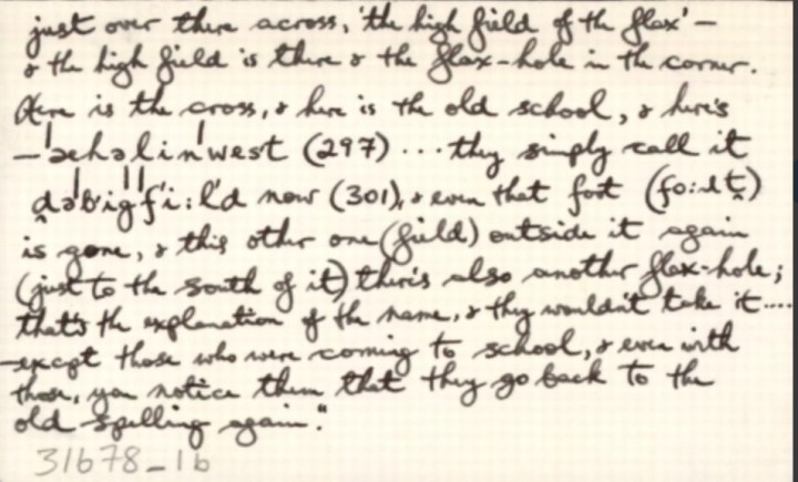
And there is the correct pronunciation, (Aughalin) it means ‘the field of the flax’ and the flax field is staring them just over there across ‘the high field of the flax’ – and the high field is there and the flax-hole in the corner. Here is the cross (Wall’s Cross), and here is the old school, and here’s ‘achalinwest’ (297) …… they simply call it The Big Field now (301) and even that fort is gone and this other one (field) outside it again (just to the south of it) there’s also another flax-hole (there) ….’.
Amazingly then, in spite of all this overwhelming local knowledge and traditional usage, in the Placenames (Co. Limerick) Order 2003 the townland of Ahalin is given as Aughalin (which is ok) and the official Irish version of the townland is given as Áith Liní (which is not). In Irish ‘Áith’ means ‘a kiln’ and there is some evidence from old maps of the area that there were at least two disused kilns in the area in question. However, ‘Liní’ has no obvious meaning or no local connotations. (To add insult to injury, of course, the same Placenames (Co. Limerick) Order 2003 also refers to Cloncagh instead of the more traditional Clouncagh, and Cluain Cath instead of the more correct Cluain Catha – but that’s a story for another day!)
The more correct rendering in Irish of the anglicised word Ahalin (or Aughalin) is, in fact, Achadh Lín which directly translates as ‘the field of the flax’. This is the Irish version used locally to this day – the new school in Ahalin (opened in October 1963) is known as Scoil Mhuire, Achadh Lín. In fact, if one does even the minimum of research (i.e. talking to the locals) they will without hesitation tell you exactly where ‘the field of the flax’ is situated.
I have long been fascinated by the fact that not too long ago, well maybe at some time during the nineteenth century, flax was grown in the parish of Knockaderry in County Limerick and there was a flax-hole or flax-dam in my own neighbouring townland, and, as Seamus Heaney describes so well in his poem, ‘Death of a Naturalist’ :
All year the flax-dam festered in the heart
Of the townland; green and heavy headed
Flax had rotted there, weighted down by huge sods.
So how come we have a townland in rural County Limerick which is associated with the growing of flax? More than likely it was an endeavour of the local landlords, the D’Arcy family who at one time lived in the townland of Ahalin and later moved to Knockaderry House or maybe the growing of flax was promoted by the Fetherson or Fitzgerald families who also owned substantial estates and were associated with Ahalin.
At the time of Griffith’s Valuation, completed in County Limerick in June 1853, Robert Fetherston held land in Ahalin in the parish of Clonelty[1], barony of Glenquin and at Bruree, barony of Connello Upper, County Limerick. In February 1855 his 565 acres at Ahalin, barony of Glenquin, on which there was a “neat cottage residence suited for a gentleman’s family”, were advertised for sale. This residence and some land were sold to Mr J.D. Fitzgerald[2] Member of Parliament for £2,350. The “cottage” in question was located in the townland of Ahalin directly behind where Mr Dave Downes and family now live. The holding consisted of the main dwelling house, a stable, a coach house, two cow houses, a piggery, a fowl house, a boiling house and a barn.
It is this Mr. Fitzgerald, who was appointed Attorney General for Ireland in 1856 and who served as MP for Clare (1852 – 1860), who gave the land for the first National School in Ahalin, which was opened in 1867. It is also very probable that it is this same Mr Fitzgerald MP, or his agent, who Master Burke is referring to when he says ‘some eejit came in 1867 and he put up on the old school AHALIN N.S. and you could not correct it!’ This suggests that Master Burke would have been happier with ‘Aughalin’ rather than ‘Ahalin’ as the correct anglicisation of the townland – as this is nearest to the Irish version of the placename, Achadh Lín.
In more recent times this cottage was the property of the Flynn brothers. In the returns of the 1901 Census, there were six people living here: Patrick Flynn aged 30, Kate Flynn aged 27, Michael Flynn aged 25, Julia Flynn aged 22, Philip Flynn aged 18 and Martin Flynn aged 12. In the Census returns for 1911, it seems that Michael and Julia have left the family home and Molly Greaney (aged 16) is registered as a General Domestic Servant by the family. The property was still owned by the Flynns up to the late 1950’s and at that time Philip (who was blind) and Martin were the two surviving brothers living in the cottage. It is said locally that they were the first house in the parish to own a radio. Molly O’Neill was their housekeeper up to the end. Before that Cis Harrold was the housekeeper. She was a sister to Mike, Willie and Brian Harrold and an aunt to Batt O’Connor.
As far back as 1654, the Limerick Civil Survey records a tuck mill[3] for flax (and later for grain up to 1924) in nearby Ballinoe. This mill was known as Reeves’s Mill and was located where the Enright’s own land today near Ballinoe Bridge on the Kilmeedy side of Ballinoe Cross near where Johnny Corkery and his family now live. In Bailiúchán na Scol, a folklore project organised by the Folklore Commission in National Schools throughout the country in 1937–38 Nora Nash[4] from Ballinoe and attending the Girls School in Ahalin stated that ‘flour was made locally in Re(e)ves’ Mill in Ballynoe’ and she further states that ‘it is to be seen still at Enright’s where the mill was’. This Mill was built on the banks of the Ábha na Scáth river which rises near Knockfierna and flows through Clouncagh and into the River Deel near Bunoke Bridge.

We also know from research carried out by the Rathkeale Historical Society that as early as 1709 Thomas Southwell (Rathkeale), whose family had inherited some of the old Billingsley/Dowdall estate (mainly centred in Kilfinny), introduced over 120 Palatine refugee families to the townlands of Courtmatrix, Killeheen, Ballingrane and Pallas(kenry). These families augmented an already established English settlement which had been introduced to assist in the development of the linen/flax industry in the West Limerick area.
Local historian, Sean Kelly in the NCW Historical Journal, The Annual Observer, in his excellent article on the history of Phelans Mill (situated where Objekt Design Space have their home accessory store today) states that for a time in the 1800’s this mill (then under the ownership of Robert Quaid and his family) was used as a scutching mill for flax and that there was a flax-dam and bleaching area nearby on the banks of the Arra River near where Dr O’Brien and Dr Barrett once resided and on land which is now owned by Ballygowan Mineral Water Company.
So while flax growing, and the linen industry it supported, was a predominantly Northern Ireland industry, remnants of it were also to be found in Munster and Limerick and even in Knockaderry itself! It is no surprise, therefore, to come across references to flax and the linen industry in the local placenames such as Ahalin. Readers may also be aware of another placename in Limerick, Monaleen, which is from the Irish ‘Móin a Lín’, literally ‘the flax meadow’ or ‘field of flax’.
Flax, itself, was a very labour intensive crop to grow and demanded much skill. The land had to be ploughed, harrowed, cross ploughed, and harrowed again and rolled. The seed was then sown, harrowed in and rolled again. Nature and the elements took over, but the better the seedbed, the better would be the crop. Much depended on the ploughman. Usually, he was a quiet fellow of good skill, much in harmony with his pair of horses. The excellence of linen depended on this quiet fellow, who ploughed a straight furrow. There was much preparation for flax growing and it was said that it took more out of the land than any other crop.
Nature responded, and in due course, thousands of flax stems grew up, three to four feet in height. A tiny blue blossom appeared on their tips, followed by a natural coloured seed pod; and the flax was ready for pulling.
Flax pulling by hand was a back-breaking job, taken on by casual workers, who needed the cash. Hand pulling was necessary because the whole stem, from root to tip, was required to give the longest fibre, for the finest quality linen cloth. The pulled flax was tied up in beats (sheaves) and put in rows or stooks on the flax field. The stooks were collected and put into flax holes, or dams, and kept under water for ten to fourteen days. This was to `rat’ or `rot’ the inside wood part from the outside fibres.
Then began the most difficult job in the making of linen, lifting the heavy, smelly, slimy, wet beats from the flax hole to the bank. Men had to work for hours, up to the waist in this wet clabber, while others took the beats and spread them on the fields to dry or bleach
Spreading was also a back-breaking job, as was lifting some days later, when dry. The flax was ready for scutching, a dusty and dangerous art. This meant the removal of the centre wood part from the outside fibres and was done when the scutcher pressed handfuls of flax against a large four-bladed flail revolving at speed. It cut away the wood part and left the scutcher with handfuls of long blonde fibres, like a young lady’s head of long blonde hair. Many an arm or hand was cut off in this process. The wood part was known as ‘shives’ which were burned as waste.
So, where can we find this ‘high field of the flax’ today or even the flax-hole in the corner of the field? As we have already noted from comments made by Master Burke to the authorities at the time it seems the flax field was situated between Wall’s Cross and the old school in Ahalin. As already mentioned, if one does even the minimum of research in the area locals will without hesitation tell you exactly where ‘the field of the flax’ is situated. Most local sources (whom I have spoken to) say that the ‘flax field’ is today owned by Mickey Magner and the field lies to the left of what is locally known as Ahalin Avenue. In times gone by there was a fort in the middle of this field but all evidence of this fort has since been removed although it can still be seen clearly in some old Ordnance Survey maps of the area.
So, it seems that while evidence of a fort can be obliterated from the landscape the folk memory associated with the growing of flax in the area cannot. The beautiful, enigmatic placename of Aughalin or Achadh Lín and its rich history lives on strongly in the folk memory of the people of Knockaderry to this day.

[1] Clonelty Parish, roughly corresponding to the parish of Knockaderry today. The townland of Aughalin consisted of 571 acres, 3 roods and 2 perches.
[2] John David Fitzgerald of Dublin was the son of David Fitzgerald, a Dublin merchant. He was Member of Parliament for Ennis 1852-1860 and was appointed Attorney General for Ireland in 1856. At the time of Griffith’s Valuation, he held land in the parish of Quin, barony of Bunratty Upper, County Clare and in the parish of Rathkeale, barony of Connello Lower, County Limerick. In 1860 he married his second wife Jane Mary Matilda Southwell, sister of the 4th Viscount Southwell. In 1882 he was made a life peer as Baron Fitzgerald of Kilmarnock. In the 1870s he owned 1,393 acres in County Clare and 1,324 acres in County Limerick including ‘a gentleman’s cottage’ and land in Aughalin.
[3] The tuck mill was used in the woollen industry to improve the quality of the woven fabric by repeatedly combing it, producing a warm worsted fabric.
[4] Bailiúchán na Scol, Imleabhar 0490, Leathanach 42. Here, just to add to the confusion, the school is named as Áth an Lín (Cailiní), Baile an Gharrdha, (Uimhir Rolla 9633).

You must be logged in to post a comment.