I like to spend my lazy days in the garden. When Kate and I set up home in Knockaderry in 1979, we inherited a garden and a red setter called Kelly. Then there was the recently acquired three-quarters of an acre, which was a very overgrown, forbidding blank canvas. The previous owners had made some effort and had put in a new bed of floribunda roses – the variety was Peace. There were other older roses there also, from previous owners, right back to Miss Airey, the original owner of the house. Miss Airey was a teacher in the old national school in Ahalin, and she built the house in 1935 and lived there with her companion, Mrs Sheehy. There were two or three Queen Elizabeth roses holding pride of place, which had been planted in 1952 to commemorate Queen Elizabeth’s coronation that year. They were still hale and hearty when we arrived in September 1979, and they are still going strong today!
Kelly helped us settle in. He was a beautiful Red Setter who had come all the way from Scarborough with the previous owners, the O’ Rourkes. He slept in the back bedroom, and he ruled the roost. Each afternoon, he escorted the school kids to the bend in the road on their way home from school, at a time when school kids still walked to school. One evening, Frank Moore called to fix our phone, and he rang the doorbell to discover that both Kate and I were still at work. Kelly soon discovered the intruder, and he came and sat in his sitting position, strategically blocking Frank’s escape. He emitted the odd low growl until we arrived home at five o’clock, and Frank was glad to be released from his captivity. Until recently, and especially when Mary and Don were young and still at home, we always had a dog. We had numerous red setters, Susie the Old English Sheepdog, a Lassie-type collie, a Cocker Spaniel named Robbie (Fowler), and a Golden Retriever from hell called Oatie!
However, to be brutally honest, when we took up residence, the garden, like the house, was somewhat of a shambles! I remember distinctly going into the Bank of Ireland branch in Newcastle West in April 1979 to cash my monthly pay cheque, which you had to do in those days. The assistant manager of the bank, Eamonn Mellett, called me over for a chat, and during the conversation, he casually asked me if I was still interested in buying ‘that house out in Knockaderry’! I told him that I was, and he said that if that was the case, the bank would be willing to provide a mortgage for the property. Believe me, that’s how business was done in those days!
Huge amounts of time, effort and study went into planning and developing our garden. I knew that I needed to study up on shrubs, especially roses, or they would surely die! Fair to say I researched the topic to Master’s degree level! I had many favourite textbooks, but my favourites were: The Wisely Book of Gardening published by The Royal Horticultural Society, Be Your Own Rose Expert by Dr D.G. Hessayon, The Gardener’s Book of Hardy Herbaceous Plants by Wendy Carlile, and A Garden for All Seasons published by The Reader’s Digest. Having done all this research, however, long before Google took hold, I finally realised that, unlike many other less finicky shrubs and plants, it’s almost impossible to kill a rose!
There are two great advantages of having gardening as a hobby – it is great therapy and a very humbling experience. Despite the optimistic messages in the glossy magazines, not everything grows, and one always has to take into account that fourth dimension, the fact that some shrubs and trees grow too big, too fast. Today, I look back in wonder at the improvements made over the years and the huge changes that have occurred on our once overgrown and neglected piece of land over the past forty-five years. I have a photo somewhere of a tiny birch sapling that my daughter Mary brought home from school when she was in First Class, and today that birch proudly dominates our driveway in Kiltanna. This is one of the advantages of gardening: we plant seeds and shrubs and trees knowing that another generation will shelter under their magnificent branches in years to come.
Mary’s sapling birch has grown to dominate the driveway in Kiltanna
The second therapeutic value of gardening is especially useful for those who like to be in control of things. Work and relationships may seem at times to be hopelessly beyond our control, but our garden can give us a semblance of control over this small patch of the universe. We can mow and clip and prune and spray and fertilise to our heart’s content and imagine that we are at least the masters of all we survey if we so wish. All is right with the world within the neat borders of our own Eden. This thought has largely been responsible for me maintaining my sanity over the years!
During the COVID pandemic in 2020, I undertook a fairly big project, and between the 9th of May and the 9th of August that year, I constructed a fire pit in the already existing scree garden up the back. I had great help because Don was working from home at the time.
May is my favourite month in the garden. For others, May is a month spoiled by exams and the crippling anxieties associated with school and college, but for me, retired like Charles Lamb of old, I stroll leisurely about – not to and from – admiring my newly budded beech trees, the grasses, the weeds, the purple Aubretia, and marvel, as Thomas Hardy does in his poem, Afterwards:
When the Present has latched its postern behind my tremulous stay,
And the May month flaps its glad green leaves like wings,
Delicate-filmed as new-spun silk, will the neighbours say,
“He was a man who used to notice such things”?
I think it was George Bernard Shaw who wisely said that ‘the best place to find God is in a garden. You can dig for him there’. Indeed, working in a garden brings us close to creation itself – it is an instrument of grace. Earlier, I mentioned that a man has made at least a start on discovering the meaning of human life when he plants shade trees under which he knows full well he will never sit. I consider myself blessed to have sat in the shade of many such trees, including the few surviving Knockaderry oaks on Quilty’s Hill, because someone planted those trees a long, long time ago.
Finally, time spent in the garden is never wasted. Wisdom is given to those who meditate in the garden; the wisdom to realise that no two gardens are the same, and thankfully, no two days are the same in any garden. Like Robert Louis Stevenson, we quickly realise that we shouldn’t judge each day by the harvest we reap but by the seeds that we sow.
The house and garden in Kiltanna, resplendent with the red Dublin Bay climbers. ‘You can’t kill a rose’!
This is a detail from the 1840 historic map showing the sculpted and structured gardens surrounding Knockaderry House, the birthplace of Sophie Peirce, and the nearby Chesterfield House. It was unusual that two ‘Great Houses’ like these would be in such close proximity to each other.
Glenroe, my native place, sits on the border between Limerick and Cork and hurling and athletics were always very strong in the area. In Canon Sheehan’s famous novel, Glenanaar, there is a fabulous account of a hurling match between neighbouring border rivals which took place in or around 1840. The game, which attracted a huge crowd, was played between the Cork side, known as The Shandons, and the Limerick side, known as The Skirmishers. The game is being fiercely contested until the captain of The Skirmishers is taken ill, and he can play no further part in the battle. There is a famous intervention by a local, known as The Yank, who has recently returned to his native place after spending many years in the USA. The Yank agrees to replace the injured captain of The Skirmishers, and he saves the day and a hard-fought victory is won. After the heroics of The Yank, an onlooker is heard to say that ‘there was nothing seen like that since Terence Casey single-handedly bate the parishes of Ardpatrick and Glenroe’.
********
Knockaderry, too, has flirted with fiction. Séan Ó Faoláin was one of the most influential figures in 20th-century Irish culture. A short-story writer of international repute, he was also a leading commentator, critic and novelist. He was the son of Bridget Murphy from Loughill East and Denis Whelan, an RIC constable who had been stationed in the RIC barracks in the village of Knockaderry in the 1890s. Every summer until he was 17, the young Ó Faoláin came to Rathkeale, to Knockaderry and to Loughill East on his holidays. He wrote with great passion about these local places in his autobiography, Vive Moi – and his first novel, in 1933, A Nest of Simple Folk, was based on that disputed territory over the hill betweenà Knockaderry village and Rathkeale, encompassing the landmarks and characters of Loughill East, Balliallinan Kilcolman, Duxtown and as far as Wilton Hill. Ó Faoláin called his home in Killiney, Co. Dublin, Knockaderry.
**********
Glenroe and Knockaderry have long been central to my life. When I left Glenroe to go to boarding school in 1965, I really didn’t intend ever to return there unless I had a very good reason. Yet, fate played a hand, and my daughter Mary met and married Mike O’Brien, and they set up a home which nestles halfway between the parish church and the school. So, in recent years, I have come to cherish the second chance that I have been given. Likewise, I quickly fell in love with Knockaderry when I arrived there in 1977 to take up my first real teaching job in nearby Newcastle West. Both places hold a special place in my heart. Both places would be perfect settings for a good novel!
I love reading, and as a teacher of English literature, I have been doubly blessed in having the honour of introducing my students to some of the great fictional works written. Being a Harper Lee fan, I remember waiting for the much-anticipated publication of Go Set a Watchman in 2015. Written before her only other published novel, the Pulitzer Prize-winning To Kill aMockingbird (1960), Go Set a Watchman was initially promoted as a sequel by its publishers. It is now accepted that it was a first draft of To Kill a Mockingbird, with many passages in that book being used again. The title alludes to Jean Louise Finch’s view of her father, Atticus Finch, as the moral compass (“watchman”) of Maycomb, Alabama, and has a theme of disillusionment, as she discovers the extent of the bigotry in her home community. Go Set a Watchman tackles the racial tensions brewing in the South in the 1950s and delves into the complex relationship between father and daughter. It includes treatments of many of the characters who appear in To Kill a Mockingbird.
I had already formed a mustard seed theory in my brain that the real-life Monroeville, Alabama, of her youth became the fictional Maycomb, Alabama, of her novels. To me, Maycomb didn’t seem too different to my own special places. Lee had set her novels here for a reason: she deliberately selected her setting, and in effect, the fictional Maycomb becomes another Narnia or Middle Earth – a microcosm of all that is good and bad in 1930s America. She tells us that one went to Maycomb, ‘to have his teeth pulled, his wagon fixed, his heart listened to, his money deposited, his soul saved, his mules vetted’. She describes it as an isolated place; in effect, it is an Everyplace – the place, ‘had remained the same for a hundred years, an island in a patchwork sea of cotton fields and timber land’. It is, in effect, a remote backwater bypassed by progress, the perfect playground of her youth, the perfect setting for a novel and the perfect cauldron for change.
In Go Set a Watchman, she says that Maycomb County is ‘a wilderness dotted with tiny settlements’; it is, ‘so cut off from the rest of the nation that some of its citizens, unaware of the South’s political predilection over the past ninety years, still voted Republican.’ It is so remote, ‘no trains went there’. In actual fact, Maycomb Junction, ‘a courtesy title’, was located in Abbott County, twenty miles away! However, she tells us that the ‘bus service was erratic and seemed to go nowhere, but the Federal Government had forced a highway or two through the swamps, thus giving the citizens an opportunity for free egress.’ However, Lee tells us that few took advantage of this opportunity! Then, in one of those Harper Lee epiphany moments, one of those lightning bolts she releases now and then, she perceptively describes her hometown, and, indeed, my own home place, whether it be Glenroe or Knockaderry, as a place where, ‘If you did not want much, there was plenty.’
In To Kill a Mockingbird, she continues in the same rich vein. Maycomb is a ‘tired old town’. People moved slowly, ‘they ambled across the square, shuffled in and out of the stores around it, took their time about everything’. She tells us that, ‘There was no hurry, for there was nowhere to go, nothing to buy and no money to buy it with, nothing to see outside the boundaries of Maycomb County’, a scenario somewhat reminiscent of modern-day Knockaderry or Glenroe!
Similar to Maycomb, the setting of George Eliot’s novel, SilasMarner, has many similar echoes. The Raveloe described by Eliot is reminiscent of my beloved Knockaderry! She tells us that it ‘was a village where many of the old echoes lingered, undrowned by new voices.’ She further describes it as being, ‘Not …. one of those barren parishes lying on the outskirts of civilisation —inhabited by meagre sheep and thinly-scattered shepherds: on the contrary, it lay in the rich central plain of what we are pleased to call Merry England’. However, like Maycomb and Knockaderry and Glenroe, it was off the beaten track, ‘it was nestled in a snug well-wooded hollow, quite an hour’s journey on horseback from any turnpike, where it was never reached by the vibrations of the coach-horn, or of public opinion’. In Chapter One, Eliot declared it to be a place where bad farmers are rewarded for bad farming!
This description of Raveloe also holds great echoes with The Village as depicted in Jim Crace’s (supposedly last?!) novel, Harvest. The narrator, Walter Thirsk, tells us that, ‘these fields are far from anywhere, two days by post-horse, three days by chariot before you find a market square.’ Harvest dramatises one of the great under-told narratives of English history: the forced enclosure of open fields and common land from the late medieval era on, whereby subsistence agriculture was replaced by profitable wool production, and the peasant farmers were gradually dispossessed and displaced. ‘The sheaf is giving way to sheep’, as Crace puts it here, and an immemorial connection between people and their local environment is being broken – their world is crumbling around them. Great changes are coming and, as everyone knows by now, the only people who welcome change are babies with wet nappies!
Brian Friel’s use of Ballybeg (small town) as the setting for many of his plays and short stories is also similar in vein to these others. In ‘Philadelphia Here I Come!’, Gar Public tells us that Ballybeg is, ‘a bloody quagmire, a backwater, a dead-end’. Friel, like Lee, Eliot, and Crace, is deceptive because he is dealing with familiar things and familiar characters – shopkeepers, housekeepers, and parish priests – a very familiar rural Ireland fixed in its own time. Friel’s use of Public Gar’s alter ego – Private Gar – allows us the opportunity to see behind the superficiality of so much of this world of small-town life.
In many ways, Friel’s major theme is the failure of people to communicate with each other on an intimate level. In his play, ‘Philadelphia, Here I Come!’, we are introduced to the typically Irish practice of verbal non-communication! He, like Harper Lee, George Eliot, and Jim Crace, forces us to examine the nature of society. In Ireland, our society in the 40’s and 50’s was dominated by the church, the politician, and the schoolmaster. Ultimately, the world that Gar is leaving has failed him and his generation. But Friel is too subtle to allow us to imagine that the world Gar is about to enter in Philadelphia will be any better.
These meandering rambles are an attempt to place myself at the beginning of a work of fiction, to stand for a moment in the author’s shoes, so to speak, and see the world from their point of view. From my limited reading, it seems to me that many authors deliberately choose a world untrodden, less travelled as the setting for their novels and plays. I have mentioned some here in this piece, but I’m sure this is just the tip of the iceberg, and you will be able to reference many examples from your own reading.
Ideally, the setting for all these classics is always remote, secluded, off the map, and cut off from change and advancement. This microcosm is then filled with characters and fictional dilemmas, action and inaction. I have always been truly fascinated and awed by each author’s unique ability and ingenuity in creating and imagining these hidden worlds in their heads, and thus allowing us to enter the world of their texts. Knockaderry and Glenroe, apart from their initial flirtations with Séan Ó Faoláin and Canon Sheehan in past centuries, patiently await their twenty-first-century novelist to arrive!
Believe me, the characters are there!
… and it seems that a twenty-first-century novelist has arrived to put Knockaderry on the map! June O Sullivan’s second novel tells the amazing tale of Knockaderry woman, Sophie Peirce, the first true female trailblazer in aviation. The novel, soon to be published, recounts Sophie’s epic solo flight from Cape Town to London in 1928.
An epiphany is that moment when the penny drops, when the scales fall away from your eyes; that ‘light bulb moment’ when the mystery is solved; when the poem gives up its secret; that Eureka Moment when you realise you’ve been conned for most of your life.
The Bible has many such moments, from Eve and the apple in Genesis to Paul’s conversion on his way to Damascus in the New Testament. As Christians, we celebrate the Feast of the Epiphany each year on January 6th, which focuses on the moment Christ is revealed to the non-Jewish world; when the Magi, guided by a star, come from the East to visit their Redeemer.
Epiphanies are mental moments when we are given instant clarity, which can turn into motivation to change and charge forward. But not all epiphanies are created equally. Some demand a deep inward search, while others fly in and out of our lives swiftly, silently, almost unnoticed.
It’s great to have an epiphany, but what you do with that new clarity is what matters most. Most of our habits are so ingrained in our lives that changing behaviour is very difficult. Most epiphanies force us to see situations and ourselves in a new light. The next step takes great courage; taking that step to live out your epiphany is when real transformation happens. In my own life, I have had some powerful moments. So, here are a few examples of some of my totally random light bulb moments…..
I normally don’t do conspiracy theories, BUT I firmly believe the young Viet Cong soldier who tortured American Vietnam hero and veteran, John McCain, for seven years, when made redundant, went back to the fledgling Hoi ChiMinh University and did a doctoral thesis on the benefits of manually induced electro muscle therapy – this was then picked up in Austria or Switzerland and sanitised. Today, it’s known as DRY NEEDLING. IMHO, the overuse of dry needling by overzealous, sadistic physiotherapists will be the rock that modern physiotherapy will perish on.
Donald Trump has never, ever put America first. Indeed, most politicians of all nationalities and all political hues invariably put themselves first. However, a stopped clock is right at least twice a day, and Donald Trump was spot-on when he coined the phrase, Fake News.
In a related epiphany, have you ever noticed that all the major News Corporations are now owned by billionaire oligarchs and moguls? I wonder why. I have come to realise that much of what passes for news in today’s world is fake – atrocity after atrocity goes unreported, and not just because all the journalists have been killed by sniper fire – those who sit at home back in the studio have their hands tied behind their backs for fear they might incur the wrath of the current government.
On a slightly lighter note, did you ever notice that shampoo bottles are designed so that you will always use more than you need? You only realise this when the bottle is nearly empty.
The Catholic Church in Ireland provided an education and health system for Irish people a century before the fledgling state was formed – they deserve to be cut some slack by the newly canonised neo-liberals. That Church, to which I belong, has been under persistent attack for most of this century.
There are 756 steps between Oscar’s Restaurant and Servitar Puerto Azul Apartments in Puerto Rico, Gran Canaria!
Last year, for the first time since we settled in Knockaderry back in 1979, we had no swallows nesting in our garage by the road. In years past, we’ve had multiple pairs, but last year, 2024, was the first year we had no nest. It struck me then that swallows are the modern version of the canary down the mine. Thankfully, this year, after a very nervous wait, a lone pair arrived on May 20th – five weeks behind schedule. They built their nest and hatched four beautiful chicks for us to admire and cherish. The world is very fragile but not yet fully broken!
Global Warming never came to Knockaderry – but Climate Change is a real problem!
I’ve always contended that common sense wasn’t that common, but now I’m convinced that logic is irreparably damaged, and Warmongers now see themselves as Peacekeepers. There’s one who has financed and supplied most of the munitions for an ongoing genocide who claims to have brokered peace in nine global conflicts this year alone. Give that man the Nobel Peace Prize now, or else!!
Your role as a parent is never done. There is never a time, in good times and in bad, when you have full peace of mind, when you no longer need to worry. In reality, as a parent, you are only ever as happy as your saddest child.
Your career as a politician or as the manager of your local hurling team always ends in failure! No matter how successful you’ve been at winning championships or leagues or simply avoiding dreaded relegation, the time will come when you lose the dressing room. The people have spoken, and you must inevitably bow to the tyranny of the ballot box or your local GAA AGM!
Modern democracy is as fragile as a wasp’s nest, papery and brittle, and in my lifetime, it has been emasculated by billionaires and Russian oligarchs for their own ends.
Your health is your wealth. It is a universal truth that we take too much for granted, like being able to put on your socks or pull up your pants or get out of bed in the morning.
Cork GAA and its supporters are so well-served by the quality of their sports journalists. No other county can claim to have writers who, week in week out, report the club scene and the intercounty scene in hurling and football to such a high standard. Names like Tony Leen, John Fogarty, Maurice Brosnan, Michael Moynihan, Eoghan Cormican, Paul Rouse, Kieran Shannon and Cathal Dennehy are among my favourites. And all of those stand on the shoulders of the giants who went before them in the old Cork Examiner: Jim O’Sullivan, Michael Ellard, the great P.D. Mehigan, better known as Carbery, and my own favourite word wizard, Kevin Cashman. In my book, he was one of hurling’s finest ever writers who prized exactitude and calm knowledge, in the same way he esteemed seeing a hurler’s correct technique create lethal elegance.
Finally, to put some order on this randomness, here are eight epiphanies that have certainly changed my life for the better, and maybe they can help you in your own journey.
You aren’t what people say you are.
What matters most is what you say and feel about yourself. You get to choose. You can let others define you and tell you who you are, or you can show them who you are. Be you. The world needs you as you are.
Plan B is often better than Plan A.
The most freeing moment in your life is when you let go of what you think is best for you. Stop holding on to what is no longer working: that job, that relationship, that dream. If it feels like hard work and is causing you more pain than gain, it is time to let go.
You are not the number on the scale.
At the end of your life, after all those weight struggles, food wars, the obsession with new diets, and trying to look a certain way, it will have no relevance. You are more than a set of grades. The only thing that matters is what is in your heart. How you make people feel and how you make YOU feel is more important than how you look.
The journey is more important than the goal.
Setting and reaching goals is important, but the actual process of becoming, growing, learning, and morphing into who we need to become is the real sweet stuff that makes for a wonderful life. Enjoy the journey as much as the reward.
Being alone doesn’t mean you will be lonely.
The fear of being alone strikes the heart and makes many people panic. But when you learn to love your own company, you will see that you are never really lonely.
It will never be all done.
The to-do lists, the chores, and the things we race around to get done will never be done. It is called life. Situations, chores, and to-do lists will always unfold. Instead of focusing on the end result, be in the process and celebrate what you have accomplished, as our wonderful Limerick Hurling team does.
Emotional pain, indeed, all pain, shows up to point out to us what we need to change.
Sadness, depression, and heartache are gentle reminders to probe deeper into our lives. In the Summer of 2024, I had six weeks of agony inflicted on me by an inflamed bursa in my left hip from climbing ladders and clipping hedges. So, look at what is not working and be open to living your life in new ways. No more climbing ladders for me!
Finally, if you’re lucky, you don’t have to find your purpose; it will find you.
The transition period between who you are and where you are going can be painful, but on your journey of finding purpose, recognise that there is purpose in the pain. Each step you take is helping you carve out more of who you really are.
Wet and windy Status Yellow weather with wintry showers on the way!
I have grown accustomed to the slow, relaxed rhythm of the seasons changing in Knockaderry. I look out from my front door at a verdant tree-filled valley with its rim of hills on the horizon, stretching from Barna to Broadford and Freemount and beyond. The people in these border regions of Limerick, Cork and Kerry are prone to exaggeration, so the hills are known locally as The Mullaghareirk Mountains. This is from the old Irish, which translates as ‘the hills with the view’. The area is also known as Sliabh Luachra, which translates as ‘the hills of the rushes’, famous for its poets, polkas and slides, its sets, and half sets. The valley that I look out on is also an ancient valley with an equally ancient name, Mágh Ghréine, ‘the valley of the sun’.
Any discussion of Irish weather risks the odd cloudburst of cliche, often fuelled by naive American tourists who believe everything they read in their Aer Lingus in-flight magazine. However, we have to admit that in Ireland we have weather, while every other place on the face of the planet has a climate. Proof of this is the recent European Commission’s decision to stop talking about Global Warming and focus instead on the term Climate Change – albeit only when they realised that Global Warming didn’t apply to Ireland. Here in Ireland, it’s either Baltic or the sun is splitting the stones, usually on the same day.
The main problem here is that most of us don’t welcome rain like the people in sub-Saharan Africa would a deluge. Our inner weathervane says things like, ‘It looks like rain’, or ‘It’s trying to rain’, or ‘It’s boiling for rain’, or ‘It’s a soft day’, or even better, ‘It’s a grand soft day’ if you’re an American tourist in Adare. We say, ‘It’s lashing rain’, ‘The heavens opened’, ‘Twas bucketing rain’, ‘Twas pissing rain’, and when it rains when you’re just going to bale the hay, we say, ‘Twas only a sun shower’, just perfect rainbow weather!
I have looked out from my porch on many an April evening and admired the sheets of rain being blown towards Ahalin across Stack’s big field. I’m also reminded of Austin Clarke, my favourite Irish weather poet, who talks of ‘the mist becoming rain’. In my opinion, our biggest problem in Ireland is when we get a settled period of very fine Summer weather, the farmers invariably start praying for rain on day three, and everyone knows the strength of their lobbying power with the Man Above!
For years, my weather watching was linked to my job, just like farmers and fishermen and such. You’d hear people talking about ‘Exam Weather’ each June, and ‘Back-to-School Weather’, which always consisted of a mini heatwave in September. Invariably, the farmers were also using this long-awaited window of opportunity to literally make hay while the sun shone.
Each year for thirty-odd years in June and July, I undertook a mini-Purgatory for my sins by correcting Leaving Cert exam papers. The six or seven-week period was usually filled with sunshine and heatwaves and Munster Finals in Thurles and holidays in Ballybunion for some, while I feverishly tried to meet completely unrealistic deadlines set by mandarins in far-off Athlone. That left August to eke out a wet week in Schull, with the prospect of torrential floods from burnt-out hurricanes in the Caribbean scorching in from the Atlantic while we diligently painted smooth stones which we had earlier retrieved from the beaches in Glandore or Ballydehob, while it lashed rain from leaden skies. Since those days, I always, for some morbid reason, expect news reports in August to announce the annual destruction and flooding caused by the monsoon season in India and Bangladesh.
May has always been my favourite month. It’s probably because of my love of gardening, but May puts on a great show in the garden before the harsh wind and rain wreak havoc with those delicate leaves, shoots and grasses. I’m always reminded of Thomas Hardy’s lines in his poem, ‘Afterwards’:
And the May month flaps it’s glad green leaves like wings,
Delicate-filmed as new-spun silk …….
I have a May Garden, and by late April or early May, the climbing Dublin Bay red roses are abloom by the south-facing front door, and the bluebells and the Aubretia are cascading as they do. I marvel at the delicate new leaves on the beech trees that I got as a present from a dear cousin back in the 80s. My two oak trees, which we bought in Van Veen’s Nursery, are late as usual, and the sycamore that grew from a tiny seedling dominates the plot. Even though we continually moan about our Irish Weather, we also rely on it to supply us with a variety of joyful vitamins and feel-good hormones. Because of our unique weather, we have endless green fields, flowers, forests, lakes and pastures. And I love that special time when the thunder and lightning strike after one of those rare Azores Highs, when you can breathe in the calm smell of rain! Sunshine is delicious, rain is refreshing, wind braces us, and snow is exhilarating; there is really no such thing as bad weather in Ireland, only an endless variety of different kinds of good weather.
Knockaderry Village as it appears on the c. 1840 Ordinance Survey map showing St. Munchin’s Church, RIC police barracks, and the Fair Green which became notorious for the Faction Fights it attracted in the 1800s.
The present-day parish of Knockaderry Clouncagh which in turn corresponds to the medieval parishes of Clouncagh, Clonelty and Grange, was once known as the Tuath of Maghreny (Máigh Ghréine which translates as the ‘Valley of the Sun’). This area was ruled by local chiefs of the Uí Fhidheingte. Sources tell us that Uí Fhidheingte flourished in County Limerick from 377 AD and was recognised as one of the most prominent of the ancient kingdoms of Munster.
By circa 950 AD, the territory of the Ui Fidhheingte was divided primarily between the two most powerful septs, the Uí Cairbre and the Uí Coileán. The Uí Cairbre Aobhdha (of which O’Donovan was chief), lay along the Maigue basin in the baronies of Coshmagh and Kenry and covered the deanery of Adare, and at one point extended past Kilmallock to Ardpartrick and Doneraile. The tribes of Uí Chonail Gabhra extended to a western district, along the Deel, and into Slieve Luachra, corresponding to the baronies of Upper and Lower Connello.
Other septs within the Uí Fhidheingte were long associated with other Limerick locations; a branch of the Fir Tamnaige gave its name to Mahoonagh, while today Feenagh is the only geographical trace extant of ancient Uí Fhidheingte. Though the changes in the name of Uí Fhidheingte down to the modern Feenagh seem strange, they are quite natural when one takes into account the gradual change from the Irish to the English language with a totally different method of spelling and pronunciation and the omission of the “Uí” which was unintelligible to those acquainted only with the latter language.
Therefore, the lands around Knockaderry were settled since pre-historic times with the stone called Leacht Phadraig in Gurteen West likely dating from the Neolithic period. Local folklore has it that as part of his travels in Ireland in the 5th Century, St. Patrick visited Clouncagh where he rested a night in the townland of Gurteen West, in a place which was later part of the ‘priest’s farm’ and presbytery overlooking the present church in Clouncagh. This place is just behind where Seanie Hartnett lives with its magnificent crafted front wall. The land is owned today by a local farmer, Mike Wall. You can see the location on the old maps and it is marked as Leacht Phadraig. This was a stone on which it is said St. Patrick knelt in prayer. Unfortunately, although appearing prominently in early Ordnance Survey maps of the area it has disappeared without a trace in recent times.
Local legend has it that St. Patrick rested here on his way from Knockpatrick, through Ardagh on his way to Ardpatrick near Kilfinnane. It is said that he killed a huge serpent that occupied the fort in Clouncagh and three wells sprung up at the spot where the serpent lay dead. Indeed, it is believed locally that the three wells to the south of the fort were named by St. Patrick as Tobar Rí an Domhnaigh (Sunday’s Well), Tobar Mhuire (Our Lady’s Well), and Tobar Phadraigh (St. Patrick’s Well).
Unfortunately, local historian and academic, Dr. Liam Irwin, casts doubt and cold water on this local legend when he states that ‘the popular belief and tradition that St Patrick rested for the night in the area is sadly, groundless’ (Irwin, 149).
Cloncagh was an early ecclesiastical centre with a church, and a very large circular enclosure, and was said to be associated with St. Maidoc of Ferns. He is credited locally with the foundation of a monastery within the fort at Clouncagh. Again, however, no less an authority than Canon Begley in his acclaimed history of the diocese of Limerick, (Vol. 1) states that the association of Maidoc with Clouncagh is unsound. Again Liam Irwin agrees saying that ‘The popular belief that Christianity was introduced to the area by St. Maidoc is based on a misreading of medieval documents’ (Irwin, 149). However, the circular fort in Clouncagh which enclosed the monastic ruin and graveyard has been described by the noted Irish antiquarian, folklorist and archaeologist, T.J. Westropp, as being the largest ring fort in County Limerick.
There was also a vibrant church in Clonelty in the townland of Ballinoe and a monastic settlement in Grange and this site is still used as a cemetery to this day. From a cursory examination of placename evidence, there were probably other churches at Kilcolman, Kiltanna and Kilgulban.
Some parts of the parish were densely settled during the Early Christian era especially in and around the area of Grange civil parish, and on the low hills north of a line from Knockaderry village to Cloncagh with evidence of a considerable number of ringforts in these two areas. However, there are no ringforts in the southeast of the parish through the townlands of Gortnacreha Upper, Gortnacreha Lower, Ballyhahil, and Teernahilla. The reason for this is unclear, but as Geraldine and Matthew Stout have pointed out, these lowland areas, because of forest cover and poor drainage were not favoured for settlement, while free-draining hill slopes were, such as is found in the north of the parish around Knockaderry village (Stout, 47).
All of the townland placenames in the parish were recorded between 1200 and 1655. This is the only instance of this in West Limerick and is evidence of a land well-endowed with the trappings of human habitation since the early Norman period. Also, baile finds its way into the making of nine townland names, confirmation of land intensely settled throughout the medieval period. There is also evidence from the years of the Anglo-Norman Conquest of at least eight defensive structures being built within the parish to keep control of the newly acquired lands. This is a high density of such structures and likely indicates a land difficult to hold or perhaps a land highly prized. Rectangular enclosures were built at Ballybeggane, Ballynaroogabeg West, and Rathfreedy and moated sites were constructed at Ballybrown and Kiltanna, with two other possible sites at Rathfreedy and Ballynaroogabeg West.
The Civil Survey of 1654-6 gives details of the land ownership following the Plantation of Munster. Much of the land in Knockaderry was transferred to Colonel Francis Courtenay, a planter. In Clonelty civil parish Francis Courtenay held the following lands; Lissaniskie, Rathweillie, Ballynoe, Cuilbane and Ballyscanlane with an old ruined castle, two orchards and a mill. He also owned lands at Killgulbane, Athlinny, Ballynwroony, and Kilteana with ‘a stone house and an orchard upon it’. Cnockederry, Caharraghane, and Lisligasta were owned by Ellen Butler. In Grange civil parish, Irish Papists named James Bourke held Ballyrobin, and John Shihy owned Ballyearralla. The remainder of the parish was held by Francis Courtenay. These lands included Cloineiskrighane, Tyrenemarte, Ballyleanaine, Downegihye and Ballyngowne, Grangieoughteragh, Granghy, Ightaragh and Lissgirraie, Galloughowe and Ballymorrishine, Caruegaere, Dromuine, Gortroe, Movidy and Ardrin. In Cloncagh, Francis Courtenay owned Tiremoeny while Lt. Colonel William Piggott held Killnamony. The rest of the civil parish was owned by Irish Papists; Edmund Shehy held Ballynerougy, Gorteene, Charaghane, Ballykennedy, Ballybeggaine, Ballycolman, and Castlecrome, while William Fitzgerald owned Tyrenehelly (Simmington, 255-8).
In the late medieval period, there is evidence that tower houses were built at Ballynoe and Ballynarooga More (South) with other possible sites at Grange Lower, Knockaderry, and Ballymorrisheen. The church and tower house in close proximity at Ballynoe were likely indicators of the presence of a medieval village and the Civil Survey also notes that there was a mill nearby. However, this small urban centre was not to survive and by the early nineteenth century a new village had taken hold two kilometres to the north at Knockaderry, no doubt helped by the granting of a patent to John Jephson in 1710 to hold regular fairs in the village. Sean Liston points out that the combination of an important road junction between Dromcolliher, Newcastle West, and Rathkeale and the centre for a quarterly fair were the likely catalysts for the growth of a village at Knockaderry, and by 1841 there were seventy-one houses in the village (Liston, 10).
Regarding the records of the Catholic Church, in 1704, Hugh Conway, who lived at Gortnacreha was registered as a Catholic priest for Clouncagh, Clonelty, and Grange. During the early nineteenth century, the parish was divided with James Quillinan in charge of the Cloncagh side, and Denis O’Brien, parish priest of the Knockaderry side. When Quillinan died in 1853, O’Brien became parish priest of both sections of the parish (Begley, 630).
Clouncagh and Cloncagh seem to be interchangeable to this day on official documents and on signposts. According to Donal Begley, a native of Clouncagh who was Chief Herald of Ireland for 13 years until he retired in June 1995,
The civil parish or state parish is written as ‘Cloncagh’, and under this form are classified such records as census and valuation returns. In short ‘Clouncagh’ designated the Catholic parish and ‘Cloncagh’ the civil or state or Protestant parish (Donal Begley, 20).
In 1789 much of Knockaderry village was burned down when a candle set fire to some straw and the flames spread to neighbouring buildings. No lives were lost (Begley, 94).
In 1806 Knockaderry Parish had 450 houses and 84 Baptisms were recorded during the year.
The Census of 1821 records a population for Knockaderry Parish of 3,328, including 253 pupils at pay Hedge Schools. Pattern Day in Clouncagh was on St. Patrick’s Day.
During the Rockite Insurrection in 1822, the Knockaderry district was very much disturbed. On the night of Saturday 23 February 1822, a house was set on fire by the Whiteboys in Lissaniska and burned to the ground. Such was the lawless state of this part of the county that a letter in the Limerick Chronicle on 27th February from a correspondent near Rathkeale which was timed and dated at 9pm on Tuesday 26 February 1822 reported; ‘We are now at this moment looking out of the windows and are illuminated with houses on fire all about the country’.
The era of the hedge school phenomenon in Ireland was between 1750 and 1875. Hedge schools were the only means available to the Catholic population for the education of their children during this period. Generally speaking, these schools were sited in discreet locations. There is evidence to suggest that in the year 1824 here were three pay Hedge Schools recorded in the parish by an official report. Two in Knockaderry run by John Mulcahy and John O’Callaghan and one in Clouncagh run by Edward Conway which was located, according to Donal Begley, in the corner of ‘Hartnett’s Field’ on the Begley farm. The three schools had a total enrolment of 228. The first ‘official’ school in the parish assisted by the Board of Commissioners of National Education was established in the year 1832. This school was located in the village of Knockaderry and John O’Callaghan was appointed headmaster of the Boys’ School and Amelia O’Callaghan, his daughter, was appointed as mistress of the Girls’ school. John Croke, a relation of Archbishop Thomas Croke, the first patron of the GAA and after whom Croke Park is named, set up a hedge school in Clouncagh around 1850. William McCann and his family offered him a thatched house and local children such as the Aireys, the Baggots, the Begleys, the Hartnetts, the Hickeys, the Quaids, and the Walls made their daily trek to sit at the feet of Master Croke. The school flourished until the arrival of the first purpose-built national school which opened its doors in Ahalin in May 1867. After this, the school suffered a gradual decline although it continued to operate until the death of John Croke circa 1885.
This is a drawing of the Begley Farm in Clouncagh which includes the names of each field as it was in 1852. The asterisk in the corner of Hartnett’s Field denotes the location of the hedge school operated by Edward Conway prior to the arrival of John Croke circa 1850 (Donal Begley, 13).
During the nineteenth century, Knockaderry was a major centre for fairs in the district. Fairs were held on Ascension Day, 9th September, 29th October, and 19th December. Samuel Lewis in 1837 described the village as being on the road to Ballingarry ‘containing fifty-eight small and indifferently built houses’ (Lewis, 101).
Knockaderry village was the scene of many faction fights in the 1830s. These fights generally occurred on fair day when long-tailed families in the community met in combat on the main street of the village. These altercations were fuelled by alcohol. The major faction in the area was the Curtins who were joined on occasion by the Haughs and Mulcahys who fought the Connors’, Longs, and Lenihans. Some of the factions could muster large numbers to appear for them. On the 12th of September 1835, a report in the Limerick Chronicle stated that the Connors factions numbering three to four hundred strong paraded the main street of the village. The Curtins who were few in number withdrew.
In 1836 there was another Outrage Report of a riot that occurred between rival factions at the Knockaderry Fair held on Ascension Thursday. The opposing factions were named as The Three-Year-Olds and The Four-Year-Olds!!
During the 1830s the payment of tithes for the support of the Protestant Church was an issue that caused much tension among the Catholic community and this occasionally led to violence. On the 16th of May 1838, an Outrage Report for County Limerick stated that at Carrowmore, Cloncagh, two men serving tithe processes were surrounded and attacked by a large number of ‘country people’ and were badly beaten. This unrest followed largely as a consequence of the passing into law of the Catholic Emancipation Act in 1829 by the British Parliament. Writing in an article for the Knockaderry Clouncagh Parish Annual in 1990, Canon T. J. Lyons P.P. remarked:
The results of the passing of the Act were quickly acted upon in County Limerick. In Knockaderry and Clouncagh priests and people quickly organised themselves to build two churches, one in Knockaderry and one in Clouncagh. Fr Denis O’Brien opened and dedicated Knockaderry new church to St Munchin in 1838 and Fr Quillinan opened and dedicated Clouncagh church to the Blessed Virgin Mary in 1840.
On the night of January 6th, 1839, The Night of The Big Wind, the roof was blown off the old timber Mass House in Clouncagh. Within a year this Mass House had been replaced with a new church, St. Mary’s, which was officially opened in Clouncagh in 1840. John Cregan, who was reputed to be the last native Irish speaker in Gortnacrehy, was born on this night during the storm.
In the spring of 1839, a shortage of fuel manifested itself in the district following poor weather the previous autumn. According to the Outrage Reports County Limerick near Knockaderry village on the 21st of March 1839, 150 men and boys organised themselves and took matters into their own hands when they cut down and took away two acres of furze the property of Robert Quaid.
A detail from the 1840 historic map showing the sculpted and structured gardens surrounding Knockaderry House and Chesterfield – including their very own fish pond. It seems unusual that two ‘Great Houses’ like these would be in such close proximity to each other.
In 1840, the important minor gentry in the parish were D’Arcy Evans of Knockaderry House, James Sullivan of Chesterfield House, the Meade family of Dromin House, Dromin Deel, and the Fitzgerald family of Moviddy. D’Arcy Evans was the largest resident landlord holding 918 acres. Almost seventy percent of the land was held by absentee landlords, such as Lord Clare and the Earl of Devon who were the largest landowners in the parish with 1,629 and 1,208 acres respectively. An analysis of the Tithe Applotment Books in the 1830s shows that the holdings of tenants ranged from less than an acre to several hundred acres with the average size being thirty-two acres. Many people lived in poverty at the lower end of the social scale with ninety labourers recorded as having less than five acres (Liston, 19, 29, 30).
In the Summer of 1840 the parish was surveyed by a team led by the renowned scholar, Dr. John O’Donovan as part of the Ordnance Survey National 6” Map series. They recorded the antiquities, and the topographical features and settled on a definitive version of the various townland names which were to appear on the eventual maps produced by the survey teams. O’Donovan spent July and August 1840 in Limerick and he signed off on his work on the parish of Clonelty and Clouncagh on 25 July 1840. He was assisted in his work in Limerick by Padraig Ó Caoimh and Antaine Ó Comhraí.
O’Donovan records numerous landlords and ‘sundry Gentlemen’ owning the various townlands in the former parish of Clonelty: Aughalin with its 565 statute acres was the property of Robert Featherston who also owned extensive lands and property in Bruree, County Limerick; Ballybrown was the property of Thomas Locke, Esq.; Ballynoe was the property of the Court of Exchequer; the Glebe of Knockaderry was the property of James Darcy Evans and Knockaderry itself in 1840 was the property of Major Sullivan under James Darcy Evans; Kiltanna with its 370 acres was the property of Wellington Rose, Esq.; Rathfredagh was the property of Thomas Cullinan; Lissaniska East was the property of Lord Chief Baron O’Grady while Lissaniska West was the property of Thomas Locke, Esq.
The Census of 1841 records the population of the three civil parishes as Grange: 708; Clonelty: 1437; and Clouncagh: 1389. 52% of parishioners were living in one-room mud cabins.
The Great Famine struck the parish between the years of 1845 and 1847and many were forced to enter workhouses. Many died of famine fever and many others are forced to emigrate. The Census of 1851 records the population of the three civil parishes of Grange, Clonelty, and Cloncagh as Grange: 490; Clonelty: 942; Cloncagh: 872. Overall, in the civil parishes of Clonelty, Grange, and Cloncagh during the decade of the Great Famine from 1841 to 1851, the population fell from 3,524 to 2,686. The 1851 returns also included 382 females in an Auxiliary or Temporary Workhouse which was located in Knockaderry House. Ignoring the workhouse returns the population loss was thirty-five percent.
The Census of 1851 records that the population of Knockaderry village stayed fairly steady falling slightly from 366 to 346. This figure stands in stark contrast to the neglected state of the village today with a population no higher than fifty people. The Census also records that 50% of the surviving population were Irish speakers or at least had some knowledge of the Irish language. This figure, rather than being a positive figure illustrated the success of efforts to eradicate the Irish language from common discourse in the locality, mainly through the efforts of the national school system.
References:
Begley, Donal. John O’Byrne Croke: Life and Times of a Clouncagh Scholar. Private publication, Modern Printers, Kilkenny, 2018.
Begley, Rev. John. The Diocese of Limerick from 1691 to the Present Time. (Vol III), Browne and Nolan, Dublin, 1938.
Curtin, Gerard. EveryField Had a Name: The Place-names of West Limerick, Sliabh Luachra Historical Society, 2012.
Irwin, Liam. The Diocese of Limerick: An Illustrated History, ed. David Bracken, 2013.
Lewis, Samuel. A History and Topography of Limerick City and County. Mercier Press: Dublin and Cork, 1980.
Liston, Sean. ‘The Community of Grange, Clonelty and Cloncagh, 1805-1845’ unpublished M.A. in History and Local Studies Thesis, University of Limerick, 2001, pp 19,29,30.
Simmington, Robert C., The Civil Survey, County of Limerick, Volume IV, Published by the Stationery Office, Dublin, 1938.
Stout, Geraldine, and Matthew. ‘Early Landscapes from Prehistory to Plantation’, in F.H.A. Aalen, Kevin Whelan and Matthew Stout (eds), Atlas of Irish Rural Landscape, (Cork, 1997).
Aughalin Wood in the townland of Aughalin which probably gave Knockaderry its name – ‘Cnoc an Doire’ meaning ‘The Hill of the Oak Wood’.
The half-parish of Clouncagh/Cloncagh nestles in the heartland of rural West Limerick. It was formerly part of the Barony of Upper Connello and is bounded on the north by Rathkeale; on the east by Ballingarry; on the south by Kilmeedy and the west by its other half-parish, Knockaderry and Newcastle West. The townland and former civil parish extended over 4,540 acres of level pastoral land in the heart of West Limerick.
Clouncagh, in the recent past, was probably best known for its famous Creamery. The Co-Operative Movement had been founded by Sir Horace Plunkett in 1889 and had very strong roots in West Limerick. It was not surprising then that farmers in the Clouncagh area came together and formed the Clouncagh Co-operative Dairy Society in 1890. Gradually Clouncagh began to develop its butter-making skills and in 1939 they won the Read Cup, the most prestigious prize available to the butter-making industry in all of Ireland.
The first manager of the creamery was David O’Brien from Clonakilty. His son, Donnchadh O’Briain later served as Fianna Fail TD for West Limerick for 36 years – having the honour to serve as Parliamentary Secretary to Taoiseach Eamon De Valera for a number of years and also to Taoiseach Sean Lemass. He was one of the founding members of Fianna Fail and served as its General Secretary for many years and was first nominated to stand for Fianna Fail in the ground breaking General Election of 1933. He also served as Chief Whip for many years. He retired from politics in 1969.
The Creamery and Donnchadh O’Briain helped put Clouncagh on the map but, if the truth were told, there has always been a certain amount of confusion as to whether the place should be known as Clouncagh or Cloncagh. The placename has taken on several variations down through the years: Clouncagh, Cloncagh, Clooncagh, Cloencagh and Clonki. There are even greater variations in the Irish version with Cluain Catha, Cluain Cath, Cluain Coimdhe, Cluain-Claidheach and also Cluain Claidheach-Maodog, Cluainchladh-bhaith, Cluain-claidhblaim being some of these.
According to Donal Begley, another native of Clouncagh and former Chief Herald of Ireland until his retirement in 1995,
‘the oldest of those forms is Clonki which is formed from the root elements ‘cluain’ (a bounded area), and possibly ‘Coimdhe’, meaning the Lord, God. On that basis Clonki would signify ‘God’s enclosure’ – surely an appropriate name to describe the location of a monastery, abbey or church, such as we have in Clouncagh.
The Black Book of Limerick, a 13th– Century topographical survey of the Diocese of Limerick has a reference to a church in Cluonkai, and this is surely a reference to present day Clouncagh.
The more generally accepted, though not necessarily correct, form of the placename in Irish is Cluain Catha which would translate into English as ‘The Meadow or Enclosure of the Battle’. Meanwhile, for some time now, the anglicised versions ‘Clouncagh’ and ‘Cloncagh’ vie with one another for preference locally and the reality is that Clouncagh and Cloncagh seem to be interchangeable to this day on official documents, local signposts and in local usage.
Donal Begley, a firm believer that the correct version is Clouncagh, tells us that, traditionally,
The civil parish or state parish is written as ‘Cloncagh’, and under this form are classified such records as census and valuation returns. In short ‘Clouncagh’ designated the Catholic parish and ‘Cloncagh’ the civil or state or Protestant parish.
Rather mischievously the Wikipedia entry for Knockaderry claims that ‘during the ministry of Canon Timothy J. Lyons as parish priest, (1964 – 1994) the “u” in Clouncagh was dropped, although it can still be seen on some of the signs entering the parish’. As Donal Begley points out the ‘u’ in Clouncagh was dropped long before Canon Lyons came to the parish.
The monastic church in Clouncagh, nestling as it did within the graveyard and centrally located within the larger fort enclosure, was a centre of worship for the local Christian community until around 1700 when public Catholic worship in Ireland was proscribed by the Penal Laws. The present parish of Knockaderry – Clouncagh (bringing together the previous parishes of Cloncagh, Clonelty and Grange) seems to have come into being around 1700 when Knockaderry began to be used as a Mass venue. The village was also granted a patent for a fair in 1711 and so it became the new centre of economic activity in the area and the old monastic sites in Cloncagh and Clonelty and Grange, which had been the focus of activity for the previous one thousand years began to fade in importance. In the 17th and 18th Century the church in Cloncagh continued in use as a Church of Ireland church. By the early 19th century the church lay abandoned and in ruins.
Diocesan and Parish’ boundaries were established at the Synod of Ráth Breasail (also known as Rathbreasail) in 1111. This Synod marked the transition of the Irish church from a monastic to a diocesan and parish-based church and many present-day dioceses trace their boundaries to decisions made at the synod. Our earliest records show that Fr Hugh Conway, who resided in Gortnacrehy, was registered and appointed Parish Priest of the former medieval parishes of Clouncagh, Clonelty and Grange, the rough equivalent of the present-day parish, in 1704. However, it wasn’t until 1853 on the death of Fr James Quillinan that Fr Denis O’Brien, who was Parish Priest in Knockaderry at the time, became the Parish Priest of the united parishes of Knockadery and Clouncagh.
In the 19th Century the Catholic Mass House in Clouncagh was situated just off the byroad, behind the present day church in land owned by the Begley family. This Mass House was severely damaged on the night of January 6th, 1839, ‘The Night of the Big Wind’. The roof was blown off and the wooden structure suffered other damage and yet amazingly within a year this Mass House had been replaced with a new church, St. Mary’s, which was officially opened in Clouncagh in1840. This is the church which still stands today having undergone numerous renovations down the years.
Over the gothic entrance to the church carved in limestone is the original inscription: Clouncagh RC Church Erected 1840. Inside the church there are also inscriptions to past parish priests who were revered by the local parishioners for their pastoral work in very difficult times. In the early nineteenth century the supply of priests improved and two priests were appointed to the parish, Fr James Quillinan for Clouncagh and Fr Denis O’Brien for Knockaderry. When Fr James Quillinan died in 1853 he was buried before the altar in Clouncagh as he had been the main driving force in the construction of the new church in 1840. Fr Denis O’Brien, who had built St Munchin’s Church in Knockaderry also in 1840, then took over as the parish priest for the united parishes of Knockaderry and Clouncagh. Both priests are buried in Clouncagh where there is also a separate memorial to Fr. O’Brien to the left of the nave near the altar. This reads:
A.M.D.G.
This monument has been erected
By his devoted sister to the memory of
Rev. Denis O’Brien P.P.
Whose long and zealous pastoral charge
For 36 years has endeared his name
To his numerous and admiring friends.
He died 19th March 1868
Year of his age 60
Requiescat in Pace. Amen.
The Rev. Cornelius McCarthy is also buried within the church. He was ordained in 1848 and served in the united parishes of Knockaderry and Clouncagh and died on Christmas Day 1885. A commemorative plaque on the wall to the right of the nave reads:
In memory
Of the priestly virtues
And sterling patriotism
Of the Rev Cornelius McCarthy
Who ruled for eighteen years
As the much beloved pastor of these parishes.
It became accepted practice within the parish that the Parish Priest resided in Clouncagh and the curate, if there was one, resided in Knockaderry.
The site of the Old Graveyard and ruined church at Cloncagh, from which the area gets its name, was the site of an early monastic establishment possibly dating from the 7th – Century. Some have credited its foundation to St. Maedoc of Ferns, who died in 624AD, while others say that he may just have been its patron. The graveyard and ruined church is contained within a large circular enclosure, formed by an earthen bank and an exterior ditch (some of which has now been dismantled but visible in earlier OS maps). The diameter of the enclosure is 220 metres and it encloses an area of 9.38 acres. The church and graveyard are located centrally within the enclosure and the present day local roadway bisects it east to west.
The gable of the ruined church and in the middle foreground the impressive tomb of the D’Arcy family, local landlords.
Further evidence that the site is an early monastery is provided by three holy wells recorded in the vicinity, Lady’s Well (Tubbermurry or Tobar Muire), Sundays Well (Tobar Rí an Domhnaigh), and St. Patrick’s Well. Only St. Patrick’s Well survives. Caoimhín Ó Danachair, the prominent Irish folklorist wrote about St. Patrick’s Well in 1955 in Holy Wells of County Limerick:
St Patrick’s Well was celebrated for curing blindness. Visited especially on 17th March. The Legend goes that while praying at Leacht Phádraig (a rock about 1000 yards from the well, associated in tradition with the saint) St Patrick saw a serpent approaching the church, and banished it by throwing his prayer-book at it. The well sprang up where the book fell. A fish is seen in the well by those whose requests are to be granted. (p. 204).
There is a record of the burning of Clouncagh church in 1326 by the Irish in their war with the Normans. There are at least two burial chambers still visible today in the graveyard – one belonging to the D’Arcy family, local landlords and the others for members of the Tierney family.
The circular fort in Clouncagh showing the ruins of Cloncagh church, the graveyard and the three wells associated with St. Patrick: Lady’s Well, Sunday’s Well and St. Patrick’s Well. Detail taken from Historical Ordnance Survey Map 1840.
Usually a fort, especially one as big and imposing as the one in Clouncagh would be referred to as a ráth or a lios or a dún in Irish. We have to wonder why this is not the case with the great fort in Clouncagh. Indeed, within the parish there are examples of townlands with names such as Lisanisky (Lios an Uisce) or Rathfredagh, while the neighbouring parish to the north is Rathkeale (Ráth Caola). However, Clouncagh seems to be an exception to the rule, probably because of its vast size. In his extensive writings on the ancient churches and ring forts in County Limerick, noted Irish antiquarian, folklorist and archaeologist, T.J. Westropp M.A. M.R.I.A., mentions ‘the great fort of Dromin at Clouncagh’. He classes it as the largest ring fort in County Limerick. This fact is interesting in itself because Limerick has 2,147 ring forts taking up approximately 317 acres. P. J. Lynch who surveyed the parish of Knockaderry – Cloncagh in 1944 as part of the Irish Tourist Association Topographical and General Survey tells us that ‘locally it is considered to have been a seat of Government in ancient times’.
The Irish version of the name Cluain Catha, seems to imply that it is named after a battle but as Donal Begley has already pointed out this is but one possible translation of the placename. There is very little reference to be found in official sites of any significant battle and very little in local folklore although we do have the reference to the fact that the then wooden church was ‘destroyed by war’ in 1326 and was rebuilt.
The following account is found in the Schools Folklore Collection (1937 – 1939) from the Convent National School in Ballingarry. The teacher’s name is Sister Mary Treasa. In my opinion, it is a perfect example of local folklore stepping in with its own narrative in the absence of any concrete historical evidence to the contrary and there may also be some evidence of nationalism insinuating itself into the mix!
One young contributor to the Collection wrote:
Clouncagh means Cluain – Cath. The Meadow of the Battle. It derived its name from a great battle fought there in the 17th century between the Irish and the English. The Irish were successful in that Battle. The victors followed the retreating army from Clouncagh across the country to Ballinarouga. Ballinarouga means the town of the rout. It got its name from the fact that the English troops were put to flight there.
However, while this claim is at best very fanciful it is true that the townland of Ballinarouga (‘The Townland of the Rout’) lies directly to the east of the ring fort enclosure in Clouncagh, and it is also interesting to note that the townland of Gortnacrehy (‘The Field of the Plunder’) also lies directly to the south. So even though there is no historical evidence of major battles being fought there it does seem that, going on the evidence of the local placenames alone, there were a fair few skirmishes in the area surrounding the monastic settlement in Clouncagh. The very fact that the battle, and not the fort itself is remembered in the placename leads us to believe that like many other important monastic sites in Ireland the fort at Clouncagh may have been a great source of dispute and contention in the dim and distant past.Is not the fact that the site was surrounded by impressive defensive ramparts but further evidence of its historic importance in the local area?
As I have already discussed here the renowned scholar and antiquarian, John O’Donovan visited and surveyed the parishes of Clonelty and Cloncagh in the summer of 1840 as part of preparatory work for the 6” Ordnance Survey Map being developed at the time. Dr O’Donovan was a noted historian and the translator of TheAnnals of the Four Masters, an Irish-speaking scholar and scribe, and he was the Ordnance Survey’s overall Names Expert during their survey conducted between 1824 and 1846. It was O’Donovan’s responsibility to enter all the Irish versions of names into the Names Books, in addition to the English spelling recommended for the published maps. In effect, his role was to standardize the translations of the Irish placenames into English and as far as the Ordnance Survey were concerned his word was law.
The vast majority of placenames in Ireland are anglicized versions of Irish language names. In many cases this entailed adapting the original Irish names to a standardized English phonology and spelling. Gerard Curtin in his fabulous book, Every Field Had a Name, tells us that all of the townland placenames in the parish of Knockaderry and Clouncagh were recorded between 1200 and 1655. Curtin tells us that this is the only instance of this occurring in West Limerick and is evidence of a land well-endowed and densely populated. So when O’Donovan surveyed the parish of Knockaderry in 1840 he found a rich vein of placenames containing often mysterious and sometimes unexplained echoes of the past.
His work on this survey was rigorous and meticulous, so much so that the Ordnance Survey of Ireland Names Books are sometimes referred to as ‘O’Donovan’s Name Books’. O’Donovan spent July and August 1840 in West Limerick and he signed off on his work on the parish of Cloncagh and Clonelty on 25 July 1840. He was assisted in his work in Limerick by Padraig Ó Caoimh and Antaine Ó Comhraí (Ó Maolfabhail, xvii). Ó Maolfabhail recognises the validity and status of O’Donovan’s work when he tells us that by 1840 there were only four other counties to be completed as part of this nationwide survey and so, therefore, O’Donovan had huge experience gained already as part of his work on the survey. This experience stood him in good stead in his attempts to standardize the translations of placenames from the Irish to the English and in trying to make sense of the etymology of the various placenames he came across (Ó Maolfabhail, xvii).
The view of the remnants of the great fort at Clouncagh as it is seen today on Google Maps
The Orthography Section of the Names Books provides the various spellings for each townland or place and the Authority Section gives the source from which these variations were derived. This was a controversial part of the Survey, especially in the Irish-speaking areas of Ireland. Thomas Larcom, the head of the Ordnance Survey, and, John O’Donovan, had a clear policy when it came to the variant spellings and meanings of Irish place-names, which was to adopt ‘the version which came closest to the original Irish form of the name’. O’Donovan is following on from long accepted practice the advice and ground rules laid down by such experts as his friend and fellow academic Patrick Weston Joyce who wrote the book Irish Local Names Explained which dealt with the process of anglicizing Irish placenames. Joyce, a Limerick man from Ballyorgan, near Kilfinnane, tells us that the governing principle in anglicizing placenames from the Irish is that ‘the present forms are derived from the ancient Irish, as they were spoken, not as they were written’. He goes on to say that there had been a long standing procedure whereby ‘those who first committed them to writing, aimed at preserving the original pronunciation, by representing it as nearly as they were able in English letters’. In my view, the over-rigorous application of standardization by O’Donovan fails to take account of local variations of pronunciation and so, to this day, we are left with a dissonance between the spelling and the local pronunciation of Clouncagh.
O’Donovan, in his extensive travels throughout Ireland as part of this nationwide survey, would have come across many placenames with the popular prefix ‘Cluain’ and he seems to have decided that this should be universally rendered as ‘Clon’ in the accepted Anglicised translation. We are very familiar with many of these placenames today throughout the length and breadth of Ireland: Clonmel, Clontarf, Clonlara, Clontibret, Clonmacnoise, Cloncagh, etc. Even though his Name Books refer to ‘Clooncagh’ and ‘Cloonelty’ they would later appear as Cloncagh and Clonelty in the 6” map which was produced by the Ordnance Survey in 1843. So, dare I say it, we have none other than the eminent John O’Donovan to blame for giving us ‘Cloncagh’ despite the mild-mannered objections of many locals to this day; especially those who continue to pronounce the placename with a ‘u’.
Referring to the origins of the placename in his Name Books, he is at pains to balance the two vying possibilities: on the one hand, he acknowledges the monastic site and the possible connection to St Maedoc, while on the other hand, he states that, ‘The name, however, is now pronounced by the natives as if written Cluain Cath, which if correct would signify Battle-Field.’
In his Name Books he also references numerous historical documents which mention Clouncagh and references one story which may be relevant to the origins of the placename. He quotes from, the noted priest and academic, Dr John Lanigan’s, The Ecclesiastical History of Ireland, V.II, p 338:
Maidoc was remarkable for his hospitality and benevolence. On being informed that some relatives of his were prisoners in Hy-Conall Gabhra (141) he went to that Country, although far distant from Ferns, for the purpose of delivering them and did not desist until he induced the Chieftain, otherwise very harsh on this point, to give them up. It is added that this Chieftain was so affected by the Saint’s (p.339) conduct that he granted him a place called Cluain-Claidheach, in which he erected a Monastery (142).
In my opinion, this may go some way to explaining why Clouncagh (Clauin Catha) is an exception to the rule mentioned earlier: the fort was gifted to St. Maedoc and changed from being a fortified place to a place of worship and monastic activity as far back as the 7th century. In a way, the fort was, in effect, a trophy of war and so retained its original name to remind people of its history. Donal Begley seems to agree with this view and he asks the question:
Could it be that Cluain Catha means a ‘trophy’ townland to remind us of a notable victory won by the fort men against an enemy on the ‘battlefield’?
A close-up view of the Old Graveyard in Clouncagh showing the semi-circular rampart to the north largely still intact. The original outline of the great fort can still be made out despite changes made by the local landowner. The old church ruin and adjoining graveyard were at the centre of the original fort.
In his beautiful book, Thirty-Two Words for Field, Manchán Magan illustrates the richness and variety which the Irish language bestows on those seemingly anonymous expanses of indistinguishable fields which surround us in our beautiful countryside. He tells us that Cluain is ‘a meadow field between two woods’. This suggests a fenced off or bounded meadow, and would aptly describe the fort enclosure at Clouncagh. Today, we can but surmise as to what took place on this holy site and the significance of the placename associated with it. It may be that it was the focus of local rivalry between warring chieftains in pre-Christian times, or indeed, as was very common in early Irish society, it may have been the location of numerous old fashioned cattle raids like the famous Cattle Raid at Cooley. Or, as John O’Donovan suggests in another one of his references to olden manuscripts it may indeed have been gifted to St Maedoc by the local chieftain as a reward for restoring his daughter to life. He references a story from The Life of St Maedoc:
Before the entrance of that fort the Man of God fasted for three days. The fast being ended, the daughter of the Chief … died suddenly. The wife of the Chief, knowing that this fact was the cause of a miracle, brought the lifeless body to St Maedoc. And the servant of God being requested by her mother and by her attendants, resuscitated her from death. ……. The Chief seeing this now, did penance and left his relatives liberated to St Maedoc, and offered him the place which is called Cluainchladh-bhaith (Cluain-claidhblaim) and the Holy Man erected a Monastery there, and blessing the place itself and the Chief who gave it, retired from thence.
Today as one stands at the gateway to the old cemetery in Clouncagh the semi-circular rampart to the north of the roadway is still clearly visible while the ramparts to the south have been eroded over time and removed by local farmers trying to improve their farmsteads. Today also there is only one well in the fields to the south – St. Patrick’s Well still stands forlornly as a reminder of former glory.
So, we can see that the confusion as to whether Clouncagh or Cloncagh is the correct modern version of the placename is still contentious. Our Ordnance Survey maps, our County Council, other government agencies, indeed the Diocese, all still rely on long-outdated information found in the old civil parishes documentation and so they still refer to the place as Cloncagh while the locals with their generations of lore and accepted pronunciation seem to prefer Clouncagh. As with the etymology and orthography of other placenames in our community, such as Aughalin/Ahalin for example, local lore is often ignored and disregarded as not having sufficient authority.
In reality, I suppose, the more we delve into the blurry past the more we realise that placenames don’t correspond to a single event and are more often the accretion over time of mundane common speech which is finally calcified by someone of the calibre of John O’Donovan who stops the spinning wheel of discursive meaning and sets it in amber for future generations as he did in July 1840. Mixed metaphors aside, I suppose, we must seek forgiveness for our desire to ascribe heroic meaning to a placename if at all possible and human nature being what it is if we can entwine some simplistic nationalism in the knot then more’s the better!
Meanwhile, the locals, including such esteemed scholars as Donal Begley continue to plough their lonely furrow and seek to have restored the only version of the placename acceptable to them: Clouncagh (Cluain Catha). However, whatever our preferences the reality is that it is impossible to know with absolute certainty what the correct version is and that ensures that the original etymology of many of our placenames will always be up for discussion and debate.
Sources:
Bailiúchán na Scol, Imleabhar 0500, page 171
Begley, Donal. A Wayside Farm by the River: Clouncagh Remembered, Privately Published by the author. Printed by Reads Design, Print and Display Dublin. 2015.
Begley, Donal. John O’Byrne Croke: Life and Times of a Clouncagh Scholar. Print and Design: Modern Printers, Kilkenny. 2018.
Curtin, Gerard. Every Field Had a Name – The Place-Names of West Limerick. Sliabh Luachra Historical Society, 2012.
Joyce, P. W., Irish Local Names Explained (1923). Scholar’s Choice Edition, Creative Media Partnership, LLC, 2015.
Knockaderry Clouncagh Parish Annuals
Lanigan’s, Dr John (1758 – 1825), The Ecclesiastical History of Ireland.
Manchán Magan, Thirty-Two Words for Field: Lost Words of the Irish Landscape, Gill Books, Dublin, 2020.
Ó Danachair, Caoimhín, Holy Wells of County Limerick, in The Journal of the Royal Society of Antiquaries of Ireland, Vol. LXXXV, 1955.
Art Ó Maolfabhail, Logainmneacha na hÉireann Imleabhair: 1 Contae Luimnigh, (Baile Átha Cliath, 1990).
O’Donavan, John. Ordnance Survey Name Books
Quilty, Pat. Knockaderry Clouncagh Graveyards, a West Limerick Resources grant aided project, 2014.
Westropp, T.J., “A Survey of the Ancient Churches of the County of Limerick”, Proceedings of the Royal Irish Academy, XXV, 327 – 480.
Wider view of the townland of Clouncagh taken from same 1840 map.
Aughalin, as it appeared on the 6″ Ordnance Survey map, produced c. 1840. Aughalin Wood is clearly outlined as is the residence of the local landlord, Robert Fetherson. Directly to the South of the Knockaderry/Ballingarry road we can see clear evidence of land reclamation and the field layout is very regular. Also note the ‘Screen’ – the linear plantation to aid drainage of the Ruatach.
On October 24th 2017 I published a piece here about the etymology of the townland placename Ahalin (Aughalin) in Knockaderry in West Limerick. You can catch up on the original article here. In it, I focused particularly on the local lore and folk wisdom which still holds that the placename Ahalin (Aughalin) is translated as Acadh Lín (the field of the flax). I was able to trace the fact that this translation came about largely through the teaching and forceful personality of the local Principal teacher in Aughalin National School, Michéal de Burca in the 1930s. In fact, with very little encouragement, local people could tell me that Ahalin meant ‘the field of the flax’ and most were also able to pinpoint its location.
Today there are two English variations of the placename, the more official Aughalin, which appears on the Ordnance Survey maps and the townland has also been referred to as Ahalin since at least 1831 when it appears on the Census Returns.[1] In 1867 a weighty limestone plaque was erected on the new National School recently opened in the area – this read ‘Ahalin National School 1867’. This plaque can still be viewed today embedded in the wall of the newly constructed set-down area and parking lot in the new school in Ahalin.
There is very little problem with the English versions of the townland’s name and both (Aughalin and Ahalin) are accepted locally and are often interchangeable. What is problematic is the current official Irish translation (or re-translation) of the placename being used by the Placenames Commission. P. W. Joyce in the second of his three-volume work on the origin and history of Irish names and places, first published in 1875, tells us that, ‘In the parish of Clonelty, near Newcastle in Limerick, there is a townland taking its name from a ford called Aughalin, the ford (ath) of the lin or pool’ (Joyce, 409). In the Preface to Volume One, Joyce, a learned Limerick man from Ballyorgan, acknowledges the help received from another placenames expert, Dr John O’Donovon, when he says, ‘I have had the advantage of two safe guides, Dr John O’Donovan and the Rev William Reeves, D.D.’ (Joyce, Vol I. vii). John O’Donovan, of whom more anon, visited the parish of Clonelty, present-day Knockaderry, in July 1840 to carry out a survey as part of the original Ordnance Survey mapping exercise carried out in Ireland. He also mentions Aughalin and gives its meaning as ‘the ford of the pond or pool’. This is the obvious literal translation, ‘Áth’ being the Irish for a ford and ‘Linn’ being the Irish for a pool. (Dublin was once Dubh Linn or Blackpool!).
Amazinly, in spite of this information and scholarship and also local knowledge and traditional usage, the official Irish version of the townland is given as Áith Liní in the Placenames (Co. Limerick) Order 2003. In Irish ‘Áith’ means ‘a kiln’ and there is evidence from old maps of the area that there were at least two kilns in the area. However, if we accept that the present anglicised form of the townland, Aughalin, refers to Áith meaning kiln there is still the difficulty that ‘Liní’ has no obvious meaning and no known local connotations or associations.
Surely local lore must count for something in trying to hear the faint whispers of a once rich oral tradition from the past. Gerard Curtin deals with this in the Introduction to Every Field Had a Name when he says:
The survival of hundreds of minor place-names in the south-west County Limerick, in an area that remained Irish speaking for longer than many other areas of the county, shows the extraordinary richness of the topoynmical tradition in Irish.[2]
According to local knowledge and tradition (more than likely promoted by Michéal de Burca who taught and lived in Aughalin from the 1930s until the 1960s), the correct rendering in Irish of the anglicised word Ahalin (or Aughalin) is Achadh Lín which he translated as ‘the field of the flax’. This is the Irish version used locally to this day and the ‘new’ Primary School in Ahalin (opened in October 1963) is known as Scoil Mhuire, Achadh Lín.
My original blog post also tried to research the link between the locality and the growing and milling of flax and found that there was a history of flax growing in the locality and that as far back as 1654 the Limerick Civil Survey records a tuck mill[3] for flax (and later for grain up to 1924) in Ballinoe. This mill was known as Reeves’s Mill. This, in turn, led me to consider other possibilities as to the etymology of the place name and to research the existence of the placename over the centuries. Art Ó Maolfabhail takes such a longer view in his seminal research, Logainmneacha na hÉireann, Imleabhar I: Contae Luimní, where he outlines the etymology of the placename Áith Liní as it has appeared in various documents and other official sources down the years:
1586 it appears as Athlyne in Peyton’s Survey, p. 108
1592 it appears as Allyneghe in F5781
1655 it appears as Athliny in the Limerick Civil Survey IV, 256, and as Athlinye in the Limerick Civil Survey, 298.[4]
1659 it appears as Aheliny in Census of Ireland, c. 1659, 280.[5]
1715 it appears as Athlinny in Clarann na Gníomhas. 16.311.7576
1750 it appears as Aghelinie in Clarann na Gníomhas. 144.378.97897 and again as Aghelinnie in Clarann na Gníomhas. 144.379.97899
1761 it appears as Agaliny in Clarann na Gníomhas. 212.591.140955
1807 it appears as Agalinny or Aghalinagh in Clarann na Gníomhas. 603.137.410629
1840 it appears as Aughalin in O’Donovan’s Field Name Books and áth a linne in pencil in O’Donovan’s Field Name Books.[6] This is the anglicised form which is most commonly seen in the old Ordnance Survey maps of the 19th Century.
In light of other evidence, however, Ó Maolfabhail’s conclusion is disappointing. Having weighed all the evidence, he rejects ‘the ford of the pool’ version favoured by P. W. Joyce and O’Donovan and doesn’t even consider Michéal de Burca’s ‘field of the flax’ version. Instead, he concludes that the official place name translation should be ‘kiln of (unknown)’. He further adds: ‘Ní léir cad dó a sheasann Liní. Toisc gan abhainn a bheith san áit, measadh gurbh oiriúnaí áith (meaning kiln) ná áth (meaning ford)’.
Dr John O’Donovan, noted historian and the translator of the Annals of the Four Masters, an Irish-speaking scholar and scribe, was the Ordnance Survey’s overall Names Expert used by the Ordnance Survey during their survey conducted between 1824 and 1846. It was O’Donovan’s responsibility to enter all the Irish versions of names into the Names Books, in addition to the English spelling recommended for the published maps. For this reason, the Ordnance Survey of Ireland Names Books are sometimes referred to as O’Donovan’s Name Books. O’Donovan spent July and August 1840 in Limerick and he signed off on his work on the parish of Clonelty on 25 July 1840. He was assisted in his work in Limerick by Padraig Ó Caoimh and Antaine Ó Comhraí.[7] Ó Maolfabhail recognises the validity and status of O’Donovan’s work when he acknowledges that by 1840 there were only four other counties to be completed as part of this nationwide survey and therefore O’Donovan had the advantage gained from having completed twenty-five other counties. This experience stood him in good stead in trying to make sense of the etymology of the various placenames (Ó Maolfabhail, xvii).
One of the most important functions of the Ordnance Survey was to name the geographical features, prominent buildings and landmarks of each townland so that these could be included on the Ordnance Survey Maps when they were eventually published. We know from these Name Books that John O’Donovan visited and wrote up the account describing the antiquities and topographical features of the then parishes of Clonelty and Clouncagh in July 1840.
Information for each townland was collected and written into the Name Book under five headings: the received name, the name finally adopted for the townland and the one placed onto the 6-inch Ordnance Survey Map in 1837. The Name Book also provided the Irish form of the name and in many instances what the Irish form of the townlands’ names meant. This was the last stage of the ‘Topographical’ process. The orthography section of the Names Books provides the various spellings for each townland or place and the authority section gives the source from which these variations were derived. This was a controversial part of the Survey, especially in the Irish-speaking areas of Ireland. Thomas Larcom, the head of the Ordnance Survey, and, John O’Donovan, had a clear policy when it came to the variant spellings and meanings of Irish place-names, which was to adopt ‘the version which came closest to the original Irish form of the name’. Thus, it seems, for O’Donovan the presence or absence of topographical features like ponds or pools made little difference to him when settling on a particular name. What mattered to him was to settle on an acceptable form which remained faithful to the original in Irish.
O’Donovan‘s observations on the townland of Aughalin are to be found in these Name Books and a transcribed version can be accessed in the Field Name Books of the County and City of Limerick. It is a collection of more than 1,700 pages of transcribed notes by surveyors during the first Ordnance Survey of County Limerick, c.1840.[8] O’Donovan’s entry for Aughalin is as follows:
Aughalin, Áth a linne, ford of the pond or pool.
Aughalin – is his favoured anglicised version for the townland
-Version found in Tithe Book of Revd. J.Croker
-Version used by Revd. J. Cullinan, P.P.
Ahalin – Version found in Barony Book 1834
-Version found in County Presentment Book 1839
-Also found in Census Return 1831
Ahalina – as in Barony Map
Athliny – as found in Limerick Civil Survey 1654 – 56
In the northeast part of the parish, a quarter of a mile east of Knockaderry Village. It is bounded on the north by Ballybrown townland and the parish of Rathkeale; east by the parish of Cloncagh; south by Kilgolban townland; and west by the townland of Kiltanna. It contains 565 acres, statute measure.
This townland is the property of Robert Featherston, Esq., and has a few portions of heathy pasture in the south and south west extremity. The remainder of the townland is under tillage and pasture. Aughalin Wood is on its north west boundary, and the road from Knockaderry to Ballingarry passes south of this wood through the townland. There are also three ancient forts in the townland, one of which is on its southern boundary. Acreable rent – £1 7s.
It has to be said that O’Donovan is being very diplomatic and circumspect here. The area he refers to as being ‘heathy pasture‘ is, in fact, a large saucer-shaped marshy area known locally as The Rhootachs. Aengus Ó Fionnagáin, lecturer in Irish at the University of Limerick and a noted placenames scholar suggests that the local name given to this area of marshy land could derive from the Irish word ‘ruaiteach’ meaning ‘reddish land’. It is interesting also that O’Donovan makes mention of Aughalin Wood as being another significant topographical feature of the townland. This was a large oak wood and probably where the present-day parish of Knockaderry gets its name – Cnoc an Doire, the hill of the oak (wood).
Another local historian and writer, Gerard Curtin, in his excellent book, Every Field Had a Name – The Place-Names of West Limerick while agreeing with Ó Maolfabhail’s assessment seems to give equal credence to O’Donovan’s translation:
AUGHALIN, Áith Liní, ‘the kiln of (unknown)’ according to Ó Maolfabhail, while O’Donovan (in Field Name Books, p. 440) believed it was from Áth na Linne, ‘ford of the pool’ (Curtin, 71).
Interestingly, Curtin also mentions that the most striking feature of the landscape in Aughalin up to the present day is the marshy area in the southwest of the townland known as The Rhootachs (also Ruatach or Rhootaigh). This is the area which O’Donavon refers to as ‘a few portions of heathy pasture in the south and south-west extremity’. This covered over fifty acres c.1913.
I sent a copy of my original blog post to the Placenames Commission for their views and shortly afterwards received a reply from Dr Conchubhar Ó Crualaoich and in the reply, the popular belief that the townland name, Aughalin/Ahalin derives from ‘the field of the flax’ is totally debunked. He states:
In regard to Aughalin, I refer you to the publication Logainmneacha na hÉireann, Imleabhar I: Contae Luimní, ed. Art Ó Maolfabhail. In that publication one finds a number of historical forms of this place-name such as ‘Athliny’, ‘Aheliny’, ‘Athlinny’, ‘Aghelinie’, and a local version recorded in 1840 namely ‘áth a linne’, which are all incompatible with derivation of the final element from lín ‘of flax’, as that lacks a final vowel. The absence of a final vowel from the later official anglicised form, Aughalin and the variant Ahalin, is doubtless due to the common loss of unstressed final vowels in anglicisation (see Townlands of Wexford ). It is also noteworthy that the historical forms and the local spoken form do not reflect the long vowel in lín. Therefore, Achadh Lín cannot be the precursor to Aughalin in this instance – it is not at one with the overall historical evidence for this place-name.[9]
However, while this historical evidence certainly rules out a final lín ‘of flax’ in the Irish precursor, identity of the final element remains somewhat unclear, although it does reflect Liní, or similar, and it is for this reason, I believe, that the phonetic approximation Liní was recommended in the official Irish form of the name.[10]
However, he also puts forward an alternative theory. He says that more evidence has come to light that the surname Lyn is recorded among the Anglo-Normans in Limerick in 1374. According to Dr Ó Crualaoich:
This could have generated an Irish version such as An Lineach (gen. an Linigh) “the person called Lin < Lyn”- which in turn could be in the precursor to Aughalin, as in Áith an Linigh ‘the kiln of the person called An Lineach (< Lyn)’.
Áith ‘kiln’ is reflected in early historical forms of the name such as ‘Athlyne’ and ‘Athlini’, as áth ‘ford’ is unlikely given the absence of any river of size here.
In this regard, the presence of disused lime-kilns in this townland is notable (see Ordnance Survey 25” map).[11]
While I have not come across any evidence that a family called Lyn ever lived in the area there is the possibility that Lyn could be related to the Gaelic surname Fhloinn (Flynn) – a name common in the area until recently.
Either way, Dr. Conchubhair O Crualaoich’s final conclusion leaves little doubt – in his mind at least – that Ahalin (Aughalin) has not derived from an association with flax:
It can only be restated that the historical evidence for this place-name does not support derivation from Achadh an Lín. The word líon (gen. lín) is reflected in the evidence for a number of place-names, but this is certainly not one of them.[12]
So, it seems that the presently widely accepted local re-translation of Aughalin as ‘The field of the flax’ is just fortuitous because the memory of flax growing in the locality in the 19th century was still somewhat fresh in the collective memory in the 1930s. P. W. Joyce in Volume One of his magnum opus, The Origins and History of Irish Names and Places warns against using recent developments to explain an age-old placename:
It is very dangerous to depend on the etymologies of the people, who are full of imagination and will often quite distort a word to meet some fanciful derivation; or they will account for a name by some silly story obviously of recent invention, and so far as the origin of the name is concerned, not worth a moment’s consideration (Joyce, Vol I, p.5).
When Michéal de Búrca began teaching in Aughalin in the 1930s he used his extensive knowledge of Irish to make the rather tenuous connection with flax. However, we can now say with 20/20 hindsight that he was in error and this was but a modern example of revisionism or the shoehorning of the translation of a placename to appease the zeitgeist of the 1930s and 40s. In 1938 Michéal de Búrca helped coordinate the school’s contribution to the Duchas Schools Collection which was taken up in over 5,000 National Schools during that year. There are very interesting stories and ‘tall tales’ recounted in its pages and it is interesting to note that de Búrca, to add further complications, names the school as Áth an Lín (translated as the ford of the flax). However, in a way, whatever the Placenames Commission may think, his efforts to translate Aughalin or Ahalin, as Acadh Lín or Áth an Lín, are far more evocative than the meaningless Áith Liní, ‘the kiln of (unknown)’ proposed by Ó Maolfabhail and now held up as the ‘official’ version by the Placenames Commission and in the Placenames (Co. Limerick) Order 2003.
We already noted that Aughalin was first recorded in the sixteenth century in Peyton’s Survey of 1586 as ‘Athlyne’ (probably from the Irish Áth Linn, ‘ford of the pool’). There is also no doubt the landscape has changed considerably in the intervening 400 years. The problems which have arisen with the present Irish versions of Aughalin seem to be that a once prominent topographical feature of the landscape – namely a pond or pool – seems to have disappeared or even dried up. Gerard Curtin is of the opinion that as the landscape began to be enclosed from the early eighteenth century great improvements to the land by drainage took place over the following 200 years. We can see in the 25-inch Ordnance Survey Map of 1888-1913 that the fields to the north of this marshy area known as the Rhootachs (or Rhootiagh) are very uniform in size, suggesting planned reclamation. The original 6” map of 1843 also clearly shows what seems to have been an L-shaped screen of trees planted probably with a view to aiding drainage in the area. With this drainage on the periphery of the marsh, the level of water fell over many years. It is more than likely that in the medieval period this marshy area may have contained a body of water, such as a pool or a small lake or pond, particularly at very wet times of the year. The same map shows a crossing/trackway running from northeast to southwest through the marsh enclosed by ditches and is wide enough to drive cattle. O’Donovan would definitely have seen more evidence of this pool or wetland in 1840 than would have been in evidence in the 1930s when Michéal de Burca cast great doubt on the translation of Aughalin as ‘the ford of the pool’ because in his view, ‘there isn’t a pool within miles of this place, and there’s no ford in the place because there’s no river’.[13] In fact, the old Ordnance survey maps indicate a tributary of the Abha na Scáth river rises in The Rhootiagh. More recent maps show that the watercourse begins further to the north, a little south of the Knockaderry to Ballingarry road. This land in question is still known locally as The Rootach and is still very marshy and is presently under extensive forestry plantation. Curtin’s strong belief is that there was a ford through The Rootach from the medieval period, and thus the name, ‘the ford of the pool’ was given to the townland as a whole.[14]
This is a detail from the 25″ Ordnance Survey map produced sometime between 1888 – 1913. It is interesting to compare both maps. Note the school in Aughalin, directly south of Aughalin Wood, which was not in the earlier map and again the uniformity of the fields directly to the south of the school signifying efforts to reclaim and drain the marshy area of ‘heathy pasture’ and make it more productive.
There are, therefore, a number of plausible translations for the placename Aughalin/Ahalin since it was first mentioned in the sixteenth century. We must remember that all these variations were but phonetic representations in English of the Irish placenames then in use. Despite the lack of standardisation down the centuries, two elements remain constant – one is the ‘áth’ and the other is ‘linn’, or similar variations such as ‘liny’, or ‘linnie’. Ironically, the official version in use today is probably the most implausible one of all. Ó Maolfabhail’s safe translation is ‘Áith Liní’ which he translates as ‘the kiln of (someone unknown)’. Likewise, Michéal de Burca’s version of ‘Acadh Lín’ which he translates as ‘The field of the flax’, although still favoured today by locals, is probably stretching the language to breaking point as can be seen from Dr Ó Crualaoich’s assessment.
O’Donovan’s translation (ford of the pond or pool) deserves to be taken seriously because he, at least, visited the area and drew up a report on the antiquities, local history and topography of the parishes of Clonelty and Clouncagh as part of the Ordnance Survey team which undertook the mapping of the area in 1840.[15] It needs to be repeated that John O’Donovan, had a clear policy when it came to the variant spellings and meanings of Irish place-names, and that was to adopt ‘the version which came closest to the original Irish form of the name’. If we follow this logic then we no longer need to focus merely on topographical features and it doesn’t really matter if there is no pond or pool to be seen in the landscape today or even at the time O’Donovan visited the area.
The question, therefore, to be considered is was there a time in the dim and distant past when there was a pond or pool in Aughalin? Michéal de Burca cast doubt on O’Donovan’s and Joyce’s versions because, ‘there isn’t a pool within miles of this place, and there’s no ford in the place because there’s no river’.[16] Ó Maolfabhail follows the same line of argument when he settled on Áith meaning ‘kiln’ instead of Áth meaning ford when he says: ‘Toisc gan abhainn a bheith san áit, measadh gurbh oiriúnaí áith (meaning kiln) ná áth (meaning ford)’ (Ó Maolfabhail, p2). I have mentioned the presence in the old Ordnance Survey maps of a minor tributary of the Abha na Scáth river but really it was little more than a run off stream. However, as Curtin points out there could have been a pond or pool in the area of the Rootach in the past with a causeway or path(s) through it and all this has now disappeared because of land reclamation works and drainage over the centuries.
Therefore, there are no easy answers to our difficulty with the etymology of the placename, Aughalin. The different variations and permutations considered here will definitely not please the local people of the area who for the past three-quarters of a century at least have always translated Aughalin as Acadh Lín (The Field of the Flax). The reason I undertook this investigation in the first place was that I was unhappy with the official Irish translation given on the Logainm.ie website and the Placenames (Co. Limerick) Order 2003 where the townland of Ahalin is given as Aughalin and the official Irish version of the townland is given as Áith Liní. The big mystery for me is how did Ó Maolfabhail totally disregard the findings of such an eminent authority as Dr John O’Donovan in arriving at his final conclusion?
Hopefully, the original meaning of Aughalin/Ahalin, going all the way back to its first mention in Peyton’s Survey of 1586, has not been forever lost in translation! Hopefully, also, to misquote the eminent P.W. Joyce, this present ‘etymology of the people’ is worth more than ‘a moment’s consideration’……
Works Cited
Curtin, Gerard. Every Field Had a Name – The Place-Names of West Limerick. Sliabh Luachra Historical Society, 2012.
Joyce, P.W., The Origin and History of Irish Names and Places. Vol I. London: Longmans, Green and Co. Dublin: M.H. Gill and Son. First Published 1869.
Joyce, P.W., The Origin and History of Irish Names and Places. Vol II. London: Longmans, Green and Co. Dublin: The Talbot Press. First Published 1875.
O’Donovan, John. Field Name Books.
Art Ó Maolfabhail, Logainmneacha na hÉireann Imleabhair: 1 Contae Luimnigh, (Baile Átha Cliath, 1990).
[2] In County Limerick in the 1851 Census the baronies of the south-west, Connello Upper and Glenquin had the most number of Irish speakers, 59.4% and 58.2% respectively. See Breandán Ó Madagáin, An Ghaeilge i Luimneach, 1700 – 1900, (Baile Átha Cliath, 1974) (Curtin, 1).
[3] A tuck mill was used in the woollen industry to improve the quality of the woven fabric by repeatedly combing it, producing a warm worsted fabric.
[4] The Limerick Civil Survey IV, County Limerick (ed. Simington, 1938)
[5] Census of Ireland, c. 1659 (ed. Pender, 1939).
[6] Ó Maolfabhail, xvii, ‘leagan Gaeilge de logainm agus é scriofa le peann luaidhe, foirm gharbh é seo a breacadh síos go direach ó bhéal cainteora Ghaeilge’.
[14] Opinion of Gerard Curtin via email correspondence
[15] O’Donovan’s Ordnance Survey Letters, Limerick, Vol 1 – his report on Clonelty and Clouncagh Church ruins is signed and dated 25th July 1840 – the letters can be viewed online at www.askaboutireland.ie and also on The Royal Irish Academy website.


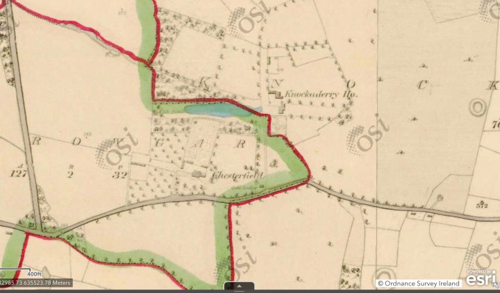


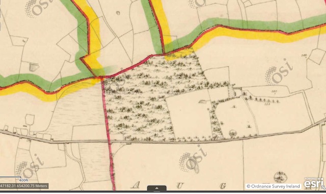


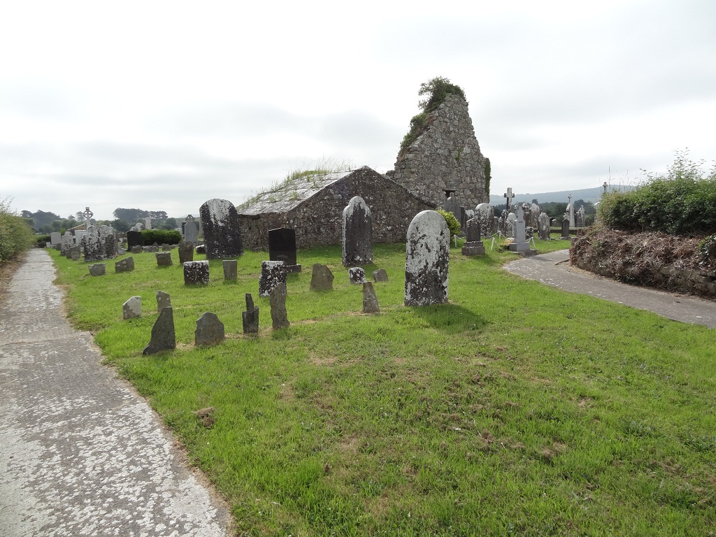
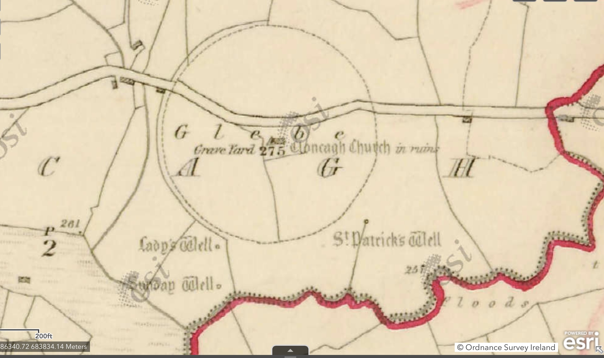


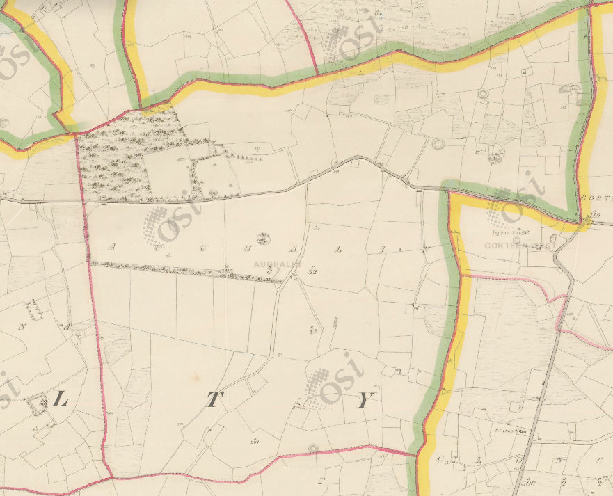
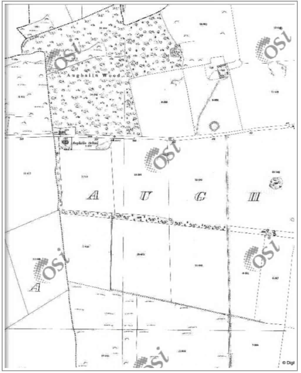

You must be logged in to post a comment.