The Etymology of the Placename Clouncagh in County Limerick

1-dsc03379 (1)
The entrance to the Old Graveyard in Clouncagh as it is today. http://www.HistoricGraves.ie

The half-parish of Clouncagh/Cloncagh nestles in the heartland of rural West Limerick.  It was formerly part of the Barony of Upper Connello and is bounded on the north by Rathkeale; on the east by Ballingarry; on the south by Kilmeedy and the west by its other half-parish, Knockaderry and Newcastle West.  The townland and former civil parish extended over 4,540 acres of level pastoral land in the heart of West Limerick. 

Clouncagh, in the recent past, was probably best known for its famous Creamery.  The Co-Operative Movement had been founded by Sir Horace Plunkett in 1889 and had very strong roots in West Limerick.  It was not surprising then that farmers in the Clouncagh area came together and formed the Clouncagh Co-operative Dairy Society in 1890. Gradually Clouncagh began to develop its butter-making skills and in 1939 they won the Read Cup, the most prestigious prize available to the butter-making industry in all of Ireland. 

The first manager of the creamery was David O’Brien from Clonakilty.  His son, Donnchadh O’Briain later served as Fianna Fail TD for West Limerick for 36 years – having the honour to serve as Parliamentary Secretary to Taoiseach Eamon De Valera for a number of years and also to Taoiseach Sean Lemass.  He was one of the founding members of Fianna Fail and served as its General Secretary for many years and was first nominated to stand for Fianna Fail in the ground breaking General Election of 1933.  He also served as Chief Whip for many years. He retired from politics in 1969.

The Creamery and Donnchadh O’Briain helped put Clouncagh on the map but, if the truth were told, there has always been a certain amount of confusion as to whether the place should be known as Clouncagh or Cloncagh.  The placename has taken on several variations down through the years: Clouncagh, Cloncagh, Clooncagh, Cloencagh and Clonki.  There are even greater variations in the Irish version with Cluain Catha, Cluain Cath, Cluain Coimdhe, Cluain-Claidheach and also Cluain Claidheach-Maodog, Cluainchladh-bhaith, Cluain-claidhblaim being some of these.

According to Donal Begley, another native of Clouncagh and former Chief Herald of Ireland until his retirement in 1995,

‘the oldest of those forms is Clonki which is formed from the root elements ‘cluain’ (a bounded area), and possibly ‘Coimdhe’, meaning the Lord, God.  On that basis Clonki would signify ‘God’s enclosure’ – surely an appropriate name to describe the location of a monastery, abbey or church, such as we have in Clouncagh.

The Black Book of Limerick, a 13th– Century topographical survey of the Diocese of Limerick has a reference to a church in Cluonkai, and this is surely a reference to present day Clouncagh.

3-dsc03375

The more generally accepted, though not necessarily correct, form of the placename in Irish is Cluain Catha which would translate into English as ‘The Meadow or Enclosure of the Battle’.  Meanwhile, for some time now, the anglicised versions ‘Clouncagh’ and ‘Cloncagh’ vie with one another for preference locally and the reality is that Clouncagh and Cloncagh seem to be interchangeable to this day on official documents, local signposts and in local usage.

Donal Begley, a firm believer that the correct version is Clouncagh, tells us that, traditionally,

The civil parish or state parish is written as ‘Cloncagh’, and under this form are classified such records as census and valuation returns.  In short ‘Clouncagh’ designated the Catholic parish and ‘Cloncagh’ the civil or state or Protestant parish.

Rather mischievously the Wikipedia entry for Knockaderry claims that  ‘during the ministry of Canon Timothy J. Lyons as parish priest, (1964 – 1994) the “u” in Clouncagh was dropped, although it can still be seen on some of the signs entering the parish’.  As Donal Begley points out the ‘u’ in Clouncagh was dropped long before Canon Lyons came to the parish. 

The monastic church in Clouncagh, nestling as it did within the graveyard and centrally located within the larger fort enclosure, was a centre of worship for the local Christian community until around 1700 when public Catholic worship in Ireland was proscribed by the Penal Laws. The present parish of Knockaderry – Clouncagh (bringing together the previous parishes of Cloncagh, Clonelty and Grange) seems to have come into being around 1700 when Knockaderry began to be used as a Mass venue.  The village was also granted a patent for a fair in 1711 and so it became the new centre of economic activity in the area and the old monastic sites in Cloncagh and Clonelty and Grange, which had been the focus of activity for the previous one thousand years began to fade in importance. In the 17th and 18th Century the church in Cloncagh continued in use as a Church of Ireland church.  By the early 19th century the church lay abandoned and in ruins. 

Diocesan and Parish’ boundaries were established at the Synod of Ráth Breasail (also known as Rathbreasail) in 1111. This Synod marked the transition of the Irish church from a monastic to a diocesan and parish-based church and many present-day dioceses trace their boundaries to decisions made at the synod. Our earliest records show that Fr Hugh Conway, who resided in Gortnacrehy, was registered and appointed Parish Priest of the former medieval parishes of Clouncagh, Clonelty and Grange, the rough equivalent of the present-day parish, in 1704.   However, it wasn’t until 1853 on the death of Fr James Quillinan that Fr Denis O’Brien, who was Parish Priest in Knockaderry at the time, became the Parish Priest of the united parishes of Knockadery and Clouncagh.

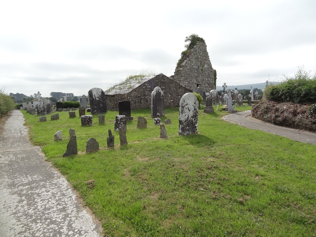
In the 19th Century the Catholic Mass House in Clouncagh was situated just off the byroad, behind the present day church in land owned by the Begley family.  This Mass House was severely damaged on the night of January 6th, 1839, ‘The Night of the Big Wind’.  The roof was blown off and the wooden structure suffered other damage and yet amazingly within a year this Mass House had been replaced with a new church, St. Mary’s, which was officially opened in Clouncagh in1840.  This is the church which still stands today having undergone numerous renovations down the years. 

Over the gothic entrance to the church carved in limestone is the original inscription: Clouncagh RC Church Erected 1840.  Inside the church there are also inscriptions to past parish priests who were revered by the local parishioners for their pastoral work in very difficult times. In the early nineteenth century the supply of priests improved and two priests were appointed to the parish, Fr James Quillinan for Clouncagh and Fr Denis O’Brien for Knockaderry. When Fr James Quillinan died in 1853 he was buried before the altar in Clouncagh as he had been the main driving force in the construction of the new church in 1840. Fr Denis O’Brien, who had built St Munchin’s Church in Knockaderry also in 1840, then took over as the parish priest for the united parishes of Knockaderry and Clouncagh.  Both priests are buried in Clouncagh where there is also a separate memorial to Fr. O’Brien to the left of the nave near the altar.  This reads:

A.M.D.G.

This monument has been erected

By his devoted sister to the memory of

Rev. Denis O’Brien P.P.

Whose long and zealous pastoral charge

For 36 years has endeared his name

To his numerous and admiring friends.

He died 19th March 1868

Year of his age 60

Requiescat in Pace. Amen.

The Rev. Cornelius McCarthy is also buried within the church.  He was ordained in 1848 and served in the united parishes of Knockaderry and Clouncagh and died on Christmas Day 1885.  A commemorative plaque on the wall to the right of the nave reads:

In memory

Of the priestly virtues

And sterling patriotism

Of the Rev Cornelius McCarthy

Who ruled for eighteen years

As the much beloved pastor of these parishes.

It became accepted practice within the parish that the Parish Priest resided in Clouncagh and the curate, if there was one, resided in Knockaderry.

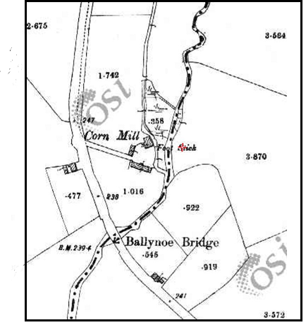
The site of the Old Graveyard and ruined church at Cloncagh, from which the area gets its name, was the site of an early monastic establishment possibly dating from the 7th – Century.  Some have credited its foundation to St. Maedoc of Ferns, who died in 624AD, while others say that he may just have been its patron.  The graveyard and ruined church is contained within a large circular enclosure, formed by an earthen bank and an exterior ditch (some of which has now been dismantled but visible in earlier OS maps).  The diameter of the enclosure is 220 metres and it encloses an area of 9.38 acres.  The church and graveyard are located centrally within the enclosure and the present day local roadway bisects it east to west. 

2-dsc03377
The gable of the ruined church and in the middle foreground the impressive tomb of the D’Arcy family, local landlords.

Further evidence that the site is an early monastery is provided by three holy wells recorded in the vicinity, Lady’s Well (Tubbermurry or Tobar Muire), Sundays Well (Tobar Rí an Domhnaigh), and St. Patrick’s Well.  Only St. Patrick’s Well survives.  Caoimhín Ó Danachair, the prominent Irish folklorist wrote about St. Patrick’s Well in 1955 in Holy Wells of County Limerick:

St Patrick’s Well was celebrated for curing blindness. Visited especially on 17th March. The Legend goes that while praying at Leacht Phádraig (a rock about 1000 yards from the well, associated in tradition with the saint) St Patrick saw a serpent approaching the church, and banished it by throwing his prayer-book at it. The well sprang up where the book fell. A fish is seen in the well by those whose requests are to be granted. (p. 204).

There is a record of the burning of Clouncagh church in 1326 by the Irish in their war with the Normans. There are at least two burial chambers still visible today in the graveyard – one belonging to the D’Arcy family, local landlords and the others for members of the Tierney family.

IMG_4294
The circular fort in Clouncagh showing the ruins of Cloncagh church, the graveyard and the three wells associated with St. Patrick: Lady’s Well, Sunday’s Well and St. Patrick’s Well. Detail taken from Historical Ordnance Survey Map 1840.

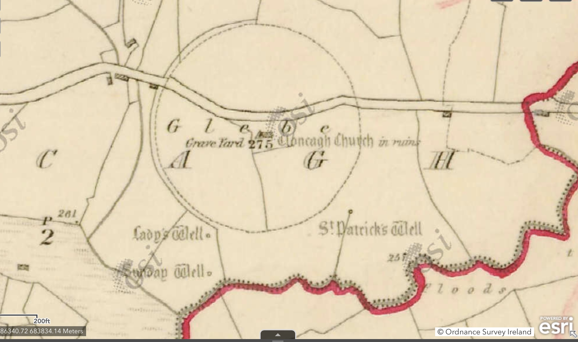
Usually a fort, especially one as big and imposing as the one in Clouncagh would be referred to as a ráth or a lios or a dún in Irish.  We have to wonder why this is not the case with the great fort in Clouncagh.  Indeed, within the parish there are examples of townlands with names such as Lisanisky (Lios an Uisce) or Rathfredagh, while the neighbouring parish to the north is Rathkeale (Ráth Caola).  However, Clouncagh seems to be an exception to the rule, probably because of its vast size.  In his extensive writings on the ancient churches and ring forts in County Limerick, noted Irish antiquarian, folklorist and archaeologist, T.J. Westropp M.A. M.R.I.A., mentions ‘the great fort of Dromin at Clouncagh’.  He classes it as the largest ring fort in County Limerick. This fact is interesting in itself because Limerick has 2,147 ring forts taking up approximately 317 acres. P. J. Lynch who surveyed the parish of Knockaderry – Cloncagh in 1944 as part of the Irish Tourist Association Topographical and General Survey tells us that ‘locally it is considered to have been a seat of Government in ancient times’.

The Irish version of the name Cluain Catha, seems to imply that it is named after a battle but as Donal Begley has already pointed out this is but one possible translation of the placename.   There is very little reference to be found in official sites of any significant battle and very little in local folklore although we do have the reference to the fact that the then wooden church was ‘destroyed by war’ in 1326 and was rebuilt.

The following account is found in the Schools Folklore Collection (1937 – 1939) from the Convent National School in Ballingarry. The teacher’s name is Sister Mary Treasa. In my opinion, it is a perfect example of local folklore stepping in with its own narrative in the absence of any concrete historical evidence to the contrary and there may also be some evidence of nationalism insinuating itself into the mix!

One young contributor to the Collection wrote:

Clouncagh means Cluain – Cath. The Meadow of the Battle. It derived its name from a great battle fought there in the 17th century between the Irish and the English. The Irish were successful in that Battle. The victors followed the retreating army from Clouncagh across the country to Ballinarouga. Ballinarouga means the town of the rout. It got its name from the fact that the English troops were put to flight there.

However, while this claim is at best very fanciful it is true that the townland of Ballinarouga (‘The Townland of the Rout’) lies directly to the east of the ring fort enclosure in Clouncagh, and it is also interesting to note that the townland of Gortnacrehy (‘The Field of the Plunder’) also lies directly to the south.  So even though there is no historical evidence of major battles being fought there it does seem that, going on the evidence of the local placenames alone, there were a fair few skirmishes in the area surrounding the monastic settlement in Clouncagh.  The very fact that the battle, and not the fort itself is remembered in the placename leads us to believe that like many other important monastic sites in Ireland the fort at Clouncagh may have been a great source of dispute and contention in the dim and distant past.  Is not the fact that the site was surrounded by impressive defensive ramparts but further evidence of its historic importance in the local area?

IMG_4306

As I have already discussed here the renowned scholar and antiquarian, John O’Donovan visited and surveyed the parishes of Clonelty and Cloncagh in the summer of 1840 as part of preparatory work for the 6” Ordnance Survey Map being developed at the time.  Dr O’Donovan was a noted historian and the translator of The Annals of the Four Masters, an Irish-speaking scholar and scribe, and he was the Ordnance Survey’s overall Names Expert during their survey conducted between 1824 and 1846.  It was O’Donovan’s responsibility to enter all the Irish versions of names into the Names Books, in addition to the English spelling recommended for the published maps.  In effect, his role was to standardize the translations of the Irish placenames into English and as far as the Ordnance Survey were concerned his word was law.

The vast majority of placenames in Ireland are anglicized versions of Irish language names.  In many cases this entailed adapting the original Irish names to a standardized English phonology and spelling.   Gerard Curtin in his fabulous book, Every Field Had a Name, tells us that all of the townland placenames in the parish of Knockaderry and Clouncagh were recorded between 1200 and 1655.  Curtin tells us that this is the only instance of this occurring in West Limerick and is evidence of a land well-endowed and densely populated.  So when O’Donovan surveyed the parish of Knockaderry in 1840 he found a rich vein of placenames containing often mysterious and sometimes unexplained echoes of the past.

His work on this survey was rigorous and meticulous, so much so that the Ordnance Survey of Ireland Names Books are sometimes referred to as ‘O’Donovan’s Name Books’.  O’Donovan spent July and August 1840 in West Limerick and he signed off on his work on the parish of Cloncagh and Clonelty on 25 July 1840.  He was assisted in his work in Limerick by Padraig Ó Caoimh and Antaine Ó Comhraí (Ó Maolfabhail, xvii).   Ó Maolfabhail recognises the validity and status of O’Donovan’s work when he tells us that by 1840 there were only four other counties to be completed as part of this nationwide survey and so, therefore, O’Donovan had huge experience gained already as part of his work on the survey.  This experience stood him in good stead in his attempts to standardize the translations of placenames from the Irish to the English and in trying to make sense of the etymology of the various placenames he came across (Ó Maolfabhail, xvii).

Cloncagh Ringfort
The view of the remnants of the great fort at Clouncagh as it is seen today on Google Maps

The Orthography Section of the Names Books provides the various spellings for each townland or place and the Authority Section gives the source from which these variations were derived.  This was a controversial part of the Survey, especially in the Irish-speaking areas of Ireland. Thomas Larcom, the head of the Ordnance Survey, and, John O’Donovan, had a clear policy when it came to the variant spellings and meanings of Irish place-names, which was to adopt ‘the version which came closest to the original Irish form of the name’.  O’Donovan is following on from long accepted practice the advice and ground rules laid down by such experts as his friend and fellow academic Patrick Weston Joyce who wrote the book Irish Local Names Explained which dealt with the process of anglicizing Irish placenames.  Joyce, a Limerick man from Ballyorgan, near Kilfinnane, tells us that the governing principle in anglicizing placenames from the Irish is that ‘the present forms are derived from the ancient Irish, as they were spoken, not as they were written’.   He goes on to say that there had been a long standing procedure whereby ‘those who first committed them to writing, aimed at preserving the original pronunciation, by representing it as nearly as they were able in English letters’.  In my view, the over-rigorous application of standardization by O’Donovan fails to take account of local variations of pronunciation and so, to this day, we are left with a dissonance between the spelling and the local pronunciation of Clouncagh.

O’Donovan, in his extensive travels throughout Ireland as part of this nationwide survey, would have come across many placenames with the popular prefix ‘Cluain’ and he seems to have decided that this should be universally rendered as ‘Clon’ in the accepted Anglicised translation.  We are very familiar with many of these placenames today throughout the length and breadth of Ireland: Clonmel, Clontarf, Clonlara, Clontibret, Clonmacnoise, Cloncagh, etc.  Even though his Name Books refer to ‘Clooncagh’ and ‘Cloonelty’ they would later appear as Cloncagh and Clonelty in the 6” map which was produced by the Ordnance Survey in 1843.  So, dare I say it, we have none other than the eminent John O’Donovan to blame for giving us ‘Cloncagh’ despite the mild-mannered objections of many locals to this day; especially those who continue to pronounce the placename with a ‘u’.

Referring to the origins of the placename in his Name Books, he is at pains to balance the two vying possibilities: on the one hand, he acknowledges the monastic site and the possible connection to St Maedoc, while on the other hand, he states that, ‘The name, however, is now pronounced by the natives as if written Cluain Cath, which if correct would signify Battle-Field.’ 

In his Name Books he also references numerous historical documents which mention Clouncagh and references one story which may be relevant to the origins of the placename.  He quotes from, the noted priest and academic,  Dr John Lanigan’s,  The Ecclesiastical History of Ireland, V.II, p 338:

Maidoc was remarkable for his hospitality and benevolence.  On being informed that some relatives of his were prisoners in Hy-Conall Gabhra (141) he went to that Country, although far distant from Ferns, for the purpose of delivering them and did not desist until he induced the Chieftain, otherwise very harsh on this point, to give them up.  It is added that this Chieftain was so affected by the Saint’s (p.339) conduct that he granted him a place called Cluain-Claidheach, in which he erected a Monastery (142).

In my opinion, this may go some way to explaining why Clouncagh (Clauin Catha) is an exception to the rule mentioned earlier: the fort was gifted to St. Maedoc and changed from being a fortified place to a place of worship and monastic activity as far back as the 7th century.  In a way, the fort was, in effect, a trophy of war and so retained its original name to remind people of its history. Donal Begley seems to agree with this view and he asks the question:

Could it be that Cluain Catha means a ‘trophy’ townland to remind us of a notable victory won by the fort men   against an enemy on the ‘battlefield’?

Cloncagh Ringfort (2)
A close-up view of the Old Graveyard in Clouncagh showing the semi-circular rampart to the north largely still intact. The original outline of the great fort can still be made out despite changes made by the local landowner. The old church ruin and adjoining graveyard were at the centre of the original fort.

In his beautiful book, Thirty-Two Words for Field, Manchán Magan illustrates the richness and variety which the Irish language bestows on those seemingly anonymous expanses of indistinguishable fields which surround us in our beautiful countryside.  He tells us that Cluain is ‘a meadow field between two woods’.    This suggests a fenced off or bounded meadow, and would aptly describe the fort enclosure at Clouncagh.  Today, we can but surmise as to what took place on this holy site and the significance of the placename associated with it.   It may be that it was the focus of local rivalry between warring chieftains in pre-Christian times, or indeed, as was very common in early Irish society, it may have been the location of numerous old fashioned cattle raids like the famous Cattle Raid at Cooley.  Or, as John O’Donovan suggests in another one of his references to olden manuscripts it may indeed have been gifted to St Maedoc by the local chieftain as a reward for restoring his daughter to life.  He references a story from The Life of St Maedoc:

Before the entrance of that fort the Man of God fasted for three days.  The fast being ended, the daughter of the Chief … died suddenly.  The wife of the Chief, knowing that this fact was the cause of a miracle, brought the lifeless body to St Maedoc.  And the servant of God being requested by her mother and by her attendants, resuscitated her from death.  ……. The Chief seeing this now, did penance and left his relatives liberated to St Maedoc, and offered him the place which is called Cluainchladh-bhaith (Cluain-claidhblaim) and the Holy Man erected a Monastery there, and blessing the place itself and the Chief who gave it, retired from thence.

Today as one stands at the gateway to the old cemetery in Clouncagh the semi-circular rampart to the north of the roadway is still clearly visible while the ramparts to the south have been eroded over time and removed by local farmers trying to improve their farmsteads.  Today also there is only one well in the fields to the south – St. Patrick’s Well still stands forlornly as a reminder of former glory. 

So, we can see that the confusion as to whether   Clouncagh or Cloncagh is the correct modern version of the placename is still contentious.  Our Ordnance Survey maps, our County Council, other government agencies, indeed the Diocese, all still rely on long-outdated information found in the old civil parishes documentation and so they still refer to the place as Cloncagh while the locals with their generations of lore and accepted pronunciation seem to prefer Clouncagh.  As with the etymology and orthography of other placenames in our community, such as Aughalin/Ahalin for example, local lore is often ignored and disregarded as not having sufficient authority.

In reality, I suppose, the more we delve into the blurry past the more we realise that placenames don’t correspond to a single event and are more often the accretion over time of mundane common speech which is finally calcified by someone of the calibre of John O’Donovan who stops the spinning wheel of discursive meaning and sets it in amber for future generations as he did in July 1840.  Mixed metaphors aside, I suppose, we must seek forgiveness for our desire to ascribe heroic meaning to a placename if at all possible and human nature being what it is if we can entwine some simplistic nationalism in the knot then more’s the better!

Meanwhile, the locals, including such esteemed scholars as Donal Begley continue to plough their lonely furrow and seek to have restored the only version of the placename acceptable to them: Clouncagh (Cluain Catha).  However, whatever our preferences the reality is that it is impossible to know with absolute certainty what the correct version is and that ensures that the original etymology of many of our placenames will always be up for discussion and debate.

Sources:

Bailiúchán na Scol, Imleabhar 0500, page 171

Begley, Donal. A Wayside Farm by the River: Clouncagh Remembered, Privately Published by the author.  Printed by Reads Design, Print and Display Dublin. 2015.

Begley, Donal. John O’Byrne Croke: Life and Times of a Clouncagh Scholar. Print and Design: Modern Printers, Kilkenny. 2018.

Curtin, Gerard. Every Field Had a Name – The Place-Names of West Limerick. Sliabh Luachra Historical Society, 2012.

Joyce, P. W., Irish Local Names Explained (1923).  Scholar’s Choice Edition, Creative Media Partnership, LLC, 2015.

Knockaderry Clouncagh Parish Annuals

Lanigan’s, Dr John (1758 – 1825), The Ecclesiastical History of Ireland.

Manchán Magan, Thirty-Two Words for Field: Lost Words of the Irish Landscape, Gill Books, Dublin, 2020.

Ó Danachair, Caoimhín, Holy Wells of County Limerick, in The Journal of the Royal Society of Antiquaries of Ireland, Vol. LXXXV, 1955.

Art Ó Maolfabhail, Logainmneacha na hÉireann Imleabhair: 1 Contae Luimnigh, (Baile Átha Cliath, 1990).

O’Donavan, John. Ordnance Survey Name Books

Quilty, Pat. Knockaderry Clouncagh Graveyards, a West Limerick Resources grant aided project, 2014.

Westropp, T.J., “A Survey of the Ancient Churches of the County of Limerick”, Proceedings of the Royal Irish Academy, XXV, 327 – 480.

IMG_4295
Wider view of the townland of Clouncagh taken from same 1840 map.

An Attempt at a Conclusive Etymology of the Placename ‘Ahalin’ in Knockaderry, County Limerick

Aughalin 1837
Aughalin, as it appeared on the 6″ Ordnance Survey map, produced c. 1840. Aughalin Wood is clearly outlined as is the residence of the local landlord, Robert Fetherson. Directly to the South of the Knockaderry/Ballingarry road we can see clear evidence of land reclamation and the field layout is very regular. Also note the ‘Screen’ – the linear plantation to aid drainage of the Ruatach.

On October 24th 2017 I published a piece here about the etymology of the townland placename Ahalin (Aughalin) in Knockaderry in West Limerick.  You can catch up on the original article here.  In it, I focused particularly on the local lore and folk wisdom which still holds that the placename Ahalin (Aughalin) is translated as Acadh Lín (the field of the flax).  I was able to trace the fact that this translation came about largely through the teaching and forceful personality of the local Principal teacher in Aughalin National School, Michéal de Burca in the 1930s.  In fact, with very little encouragement, local people could tell me that Ahalin meant ‘the field of the flax’ and most were also able to pinpoint its location.

Today there are two English variations of the placename, the more official Aughalin, which appears on the Ordnance Survey maps and the townland has also been referred to as Ahalin since at least 1831 when it appears on the Census Returns.[1]  In 1867 a weighty limestone plaque was erected on the new National School recently opened in the area – this read ‘Ahalin National School 1867’.  This plaque can still be viewed today embedded in the wall of the newly constructed set-down area and parking lot in the new school in Ahalin.

There is very little problem with the English versions of the townland’s name and both (Aughalin and Ahalin) are accepted locally and are often interchangeable.  What is problematic is the current official Irish translation (or re-translation) of the placename being used by the Placenames Commission.  P. W. Joyce in the second of his three-volume work on the origin and history of Irish names and places, first published in 1875, tells us that, ‘In the parish of Clonelty, near Newcastle in Limerick, there is a townland taking its name from a ford called Aughalin, the ford (ath) of the lin or pool’ (Joyce, 409).  In the Preface to Volume One, Joyce, a learned Limerick man from Ballyorgan, acknowledges the help received from another placenames expert, Dr John O’Donovon, when he says, ‘I have had the advantage of two safe guides, Dr John O’Donovan and the Rev William Reeves, D.D.’ (Joyce, Vol I. vii). John O’Donovan, of whom more anon, visited the parish of Clonelty, present-day Knockaderry, in July 1840 to carry out a survey as part of the original Ordnance Survey mapping exercise carried out in Ireland.  He also mentions Aughalin and gives its meaning as ‘the ford of the pond or pool’.  This is the obvious literal translation, ‘Áth’ being the Irish for a ford and ‘Linn’ being the Irish for a pool.  (Dublin was once Dubh Linn or Blackpool!).

Amazinly, in spite of this information and scholarship and also local knowledge and traditional usage, the official Irish version of the townland is given as Áith Liní in the Placenames (Co. Limerick) Order 2003.  In Irish ‘Áith’ means ‘a kiln’ and there is evidence from old maps of the area that there were at least two kilns in the area.  However, if we accept that the present anglicised form of the townland, Aughalin, refers to Áith meaning kiln there is still the difficulty that ‘Liní’ has no obvious meaning and no known local connotations or associations.

Surely local lore must count for something in trying to hear the faint whispers of a once rich oral tradition from the past.  Gerard Curtin deals with this in the Introduction to Every Field Had a Name when he says:

The survival of hundreds of minor place-names in the south-west County Limerick, in an area that remained Irish speaking for longer than many other areas of the county, shows the extraordinary richness of the topoynmical tradition in Irish.[2]

According to local knowledge and tradition (more than likely promoted by Michéal de Burca who taught and lived in Aughalin from the 1930s until the 1960s), the correct rendering in Irish of the anglicised word Ahalin (or Aughalin) is Achadh Lín which he translated as ‘the field of the flax’.  This is the Irish version used locally to this day and the ‘new’ Primary School in Ahalin (opened in October 1963) is known as Scoil Mhuire, Achadh Lín.

My original blog post also tried to research the link between the locality and the growing and milling of flax and found that there was a history of flax growing in the locality and that as far back as 1654 the Limerick Civil Survey records a tuck mill[3] for flax (and later for grain up to 1924) in Ballinoe. This mill was known as Reeves’s Mill.  This, in turn, led me to consider other possibilities as to the etymology of the place name and to research the existence of the placename over the centuries.  Art Ó Maolfabhail takes such a longer view in his seminal research, Logainmneacha na hÉireann, Imleabhar I: Contae Luimní, where he outlines the etymology of the placename Áith Liní  as it has appeared in various documents and other official sources  down the years:

  • 1586 it appears as Athlyne in Peyton’s Survey, p. 108
  • 1592 it appears as Allyneghe in F5781
  • 1655 it appears as Athliny in the Limerick Civil Survey IV, 256, and as Athlinye in the Limerick Civil Survey, 298.[4]
  • 1659 it appears as Aheliny in Census of Ireland, c. 1659, 280.[5]
  • 1715 it appears as Athlinny in Clarann na Gníomhas. 16.311.7576
  • 1750 it appears as Aghelinie in Clarann na Gníomhas. 144.378.97897 and again as Aghelinnie in Clarann na Gníomhas. 144.379.97899
  • 1761 it appears as Agaliny in Clarann na Gníomhas. 212.591.140955
  • 1807 it appears as Agalinny or Aghalinagh in Clarann na Gníomhas. 603.137.410629
  • 1840 it appears as Aughalin in O’Donovan’s Field Name Books and áth a linne in pencil in O’Donovan’s Field Name Books.[6] This is the anglicised form which is most commonly seen in the old Ordnance Survey maps of the 19th  Century.

In light of other evidence, however, Ó Maolfabhail’s conclusion is disappointing.  Having weighed all the evidence, he rejects ‘the ford of the pool’ version favoured by P. W. Joyce and O’Donovan and doesn’t even consider Michéal de Burca’s ‘field of the flax’ version.  Instead, he concludes that the official place name translation should be ‘kiln of (unknown)’.  He further adds: ‘Ní léir cad dó a sheasann Liní.  Toisc gan abhainn a bheith san áit, measadh gurbh oiriúnaí áith (meaning kiln) ná áth (meaning ford)’.

Dr John O’Donovan, noted historian and the translator of the Annals of the Four Masters, an Irish-speaking scholar and scribe, was the Ordnance Survey’s overall Names Expert used by the Ordnance Survey during their survey conducted between 1824 and 1846.  It was O’Donovan’s responsibility to enter all the Irish versions of names into the Names Books, in addition to the English spelling recommended for the published maps.  For this reason, the Ordnance Survey of Ireland Names Books are sometimes referred to as O’Donovan’s Name Books.  O’Donovan spent July and August 1840 in Limerick and he signed off on his work on the parish of Clonelty on 25 July 1840.  He was assisted in his work in Limerick by Padraig Ó Caoimh and Antaine Ó Comhraí.[7]  Ó Maolfabhail recognises the validity and status of O’Donovan’s work when he acknowledges that by 1840 there were only four other counties to be completed as part of this nationwide survey and therefore O’Donovan had the advantage gained from having completed twenty-five other counties.  This experience stood him in good stead in trying to make sense of the etymology of the various placenames (Ó Maolfabhail, xvii).

One of the most important functions of the Ordnance Survey was to name the geographical features, prominent buildings and landmarks of each townland so that these could be included on the Ordnance Survey Maps when they were eventually published. We know from these Name Books that John O’Donovan visited and wrote up the account describing the antiquities and topographical features of the then parishes of Clonelty and Clouncagh in July 1840.

Information for each townland was collected and written into the Name Book under five headings: the received name, the name finally adopted for the townland and the one placed onto the 6-inch Ordnance Survey Map in 1837.  The Name Book also provided the Irish form of the name and in many instances what the Irish form of the townlands’ names meant.  This was the last stage of the ‘Topographical’ process.   The orthography section of the Names Books provides the various spellings for each townland or place and the authority section gives the source from which these variations were derived.  This was a controversial part of the Survey, especially in the Irish-speaking areas of Ireland. Thomas Larcom, the head of the Ordnance Survey, and, John O’Donovan, had a clear policy when it came to the variant spellings and meanings of Irish place-names, which was to adopt ‘the version which came closest to the original Irish form of the name’.    Thus, it seems, for O’Donovan the presence or absence of topographical features like ponds or pools made little difference to him when settling on a particular name.  What mattered to him was to settle on an acceptable form which remained faithful to the original in Irish.

O’Donovan‘s observations on the townland of Aughalin are to be found in these Name Books and a transcribed version can be accessed in the Field Name Books of the County and City of Limerick.  It is a collection of more than 1,700 pages of transcribed notes by surveyors during the first Ordnance Survey of County Limerick,  c.1840.[8]  O’Donovan’s entry for Aughalin is as follows:

Aughalin, Áth a linne, ford of the pond or pool.

Aughalin              – is his favoured anglicised version for the townland

-Version found in Tithe Book of Revd. J.Croker

-Version used by Revd. J. Cullinan, P.P.

Ahalin                  – Version found in Barony Book 1834

-Version found in County Presentment Book 1839

-Also found in Census Return 1831

Ahalina                –  as in Barony Map

Athliny                 – as found in Limerick Civil Survey 1654 – 56

In the northeast part of the parish, a quarter of a mile east of Knockaderry Village.  It is bounded on the north by Ballybrown townland and the parish of Rathkeale; east by the parish of Cloncagh; south by Kilgolban townland; and west by the townland of Kiltanna.  It contains 565 acres, statute measure.

This townland is the property of Robert Featherston, Esq., and has a few portions of heathy pasture in the south and south west extremity.  The remainder of the townland is under tillage and pasture.  Aughalin Wood is on its north west boundary, and the road from Knockaderry to Ballingarry passes south of this wood through the townland.  There are also three ancient forts in the townland, one of which is on its southern boundary.  Acreable rent – £1 7s.

It has to be said that O’Donovan is being very diplomatic and circumspect here.  The area he refers to as being ‘heathy pasture‘ is, in fact, a large saucer-shaped marshy area known locally as The Rhootachs.  It is interesting also that he makes mention of Aughalin Wood as being another significant topographical feature of the townland.  This was a large oak wood and probably where the present day parish of Knockaderry gets its name – Cnoc an Doire.

Another local historian and writer, Gerard Curtin, in his excellent book, Every Field Had a Name – The Place-Names of West Limerick while agreeing with Ó Maolfabhail’s assessment seems to give equal credence to O’Donovan’s translation:

AUGHALIN, Áith Liní, ‘the kiln of (unknown)’ according to Ó Maolfabhail, while O’Donovan (in Field Name Books, p. 440) believed it was from Áth na Linne, ‘ford of the pool’ (Curtin, 71).

Interestingly, Curtin also mentions that the most striking feature of the landscape in Aughalin up to the present day is the marshy area in the southwest of the townland known as The Rhootachs (also Ruatach or Rhootaigh). This is the area which O’Donavon refers to as ‘a few portions of heathy pasture in the south and south-west extremity’.  This covered over fifty acres c.1913.

I sent a copy of my original blog post to the Placenames Commission for their views and shortly afterwards received a reply from Dr Conchubhar Ó Crualaoich and in the reply, the popular belief that the townland name, Aughalin/Ahalin derives from ‘the field of the flax’ is totally debunked.  He states:

In regard to Aughalin, I refer you to the publication Logainmneacha na hÉireann, Imleabhar I: Contae Luimní, ed. Art Ó Maolfabhail. In that publication one finds a number of historical forms of this place-name such as ‘Athliny’, ‘Aheliny’, ‘Athlinny’, ‘Aghelinie’, and a local version recorded in 1840 namely ‘áth a linne’, which are all incompatible with derivation of the final element from lín ‘of flax’, as that lacks a final vowel. The absence of a final vowel from the later official anglicised form, Aughalin and the variant  Ahalin, is doubtless due to the common loss of unstressed final vowels in anglicisation (see Townlands of Wexford ). It is also noteworthy that the historical forms and the local spoken form do not reflect the long vowel in lín. Therefore, Achadh Lín cannot be the precursor to Aughalin in this instance – it is not at one with the overall historical evidence for this place-name.[9]

However, while this historical evidence certainly rules out a final lín ‘of flax’ in the Irish precursor,  identity of the final element remains somewhat unclear, although it does reflect Liní, or similar, and it is for this reason, I believe, that the phonetic approximation Liní was recommended in the official Irish form of the name.[10]

However, he also puts forward an alternative theory.  He says that more evidence has come to light that the surname Lyn is recorded among the Anglo-Normans in Limerick in 1374.  According to Dr Ó Crualaoich:

This could have generated an Irish version such as An Lineach (gen. an Linigh) “the person called Lin < Lyn”- which in turn could be in the precursor to Aughalin, as in Áith an Linigh ‘the kiln of the person called An Lineach (< Lyn)’.

Áith ‘kiln’ is reflected in early historical forms of the name such as ‘Athlyne’ and ‘Athlini’, as áth ‘ford’ is unlikely given the absence of any river of size here.

In this regard, the presence of disused lime-kilns in this townland is notable (see Ordnance Survey 25” map).[11]

While I have not come across any evidence that a family called Lyn ever lived in the area there is the possibility that Lyn could be related to the Gaelic surname Fhloinn (Flynn) – a name common in the area until recently.

Either way, Dr. Conchubhair O Crualaoich’s final conclusion leaves little doubt – in his mind at least – that Ahalin (Aughalin) has not derived from an association with flax:

It can only be restated that the historical evidence for this place-name does not support derivation from Achadh an Lín.  The word líon (gen. lín) is reflected in the evidence for a number of place-names, but this is certainly not one of them.[12]

So, it seems that the presently widely accepted local re-translation of Aughalin as ‘The field of the flax’ is just fortuitous because the memory of flax growing in the locality in the 19th century was still somewhat fresh in the collective memory in the 1930s.  P. W. Joyce in Volume One of his magnum opus, The Origins and History of Irish Names and Places warns against using recent developments to explain an age-old placename:

It is very dangerous to depend on the etymologies of the people, who are full of imagination and will often quite distort a word to meet some fanciful derivation; or they will account for a name by some silly story obviously of recent invention, and so far as the origin of the name is concerned, not worth a moment’s consideration (Joyce, Vol I, p.5).

When Michéal de Búrca began teaching in Aughalin in the 1930s he used his extensive knowledge of Irish to make the rather tenuous connection with flax.   However, we can now say with 20/20 hindsight that he was in error and this was but a modern example of revisionism or the shoehorning of the translation of a placename to appease the zeitgeist of the 1930s and 40s.  In 1938 Michéal de Búrca helped coordinate the school’s contribution to the Duchas Schools Collection which was taken up in over 5,000 National Schools during that year.  There are very interesting stories and ‘tall tales’ recounted in its pages and it is interesting to note that de Búrca, to add further complications, names the school as Áth an Lín (translated as the ford of the flax).  However, in a way, whatever the Placenames Commission may think, his efforts to translate Aughalin or Ahalin,  as Acadh Lín or Áth an Lín, are far more evocative than the meaningless Áith Liní, ‘the kiln of (unknown)’ proposed by Ó Maolfabhail and now held up as the ‘official’ version by the Placenames Commission and in the Placenames (Co. Limerick) Order 2003.

We already noted that Aughalin was first recorded in the sixteenth century in Peyton’s Survey of 1586 as ‘Athlyne’ (probably from the Irish Áth Linn, ‘ford of the pool’).  There is also no doubt the landscape has changed considerably in the intervening 400 years.  The problems which have arisen with the present Irish versions of Aughalin seem to be that a once prominent topographical feature of the landscape – namely a pond or pool – seems to have disappeared or even dried up.  Gerard Curtin is of the opinion that as the landscape began to be enclosed from the early eighteenth century great improvements to the land by drainage took place over the following 200 years. We can see in the 25-inch Ordnance Survey Map of 1888-1913 that the fields to the north of this marshy area known as the Rhootachs (or Rhootiagh) are very uniform in size, suggesting planned reclamation. The original 6” map of 1843 also clearly shows what seems to have been an L-shaped screen of trees planted probably with a view to aiding drainage in the area.  With this drainage on the periphery of the marsh, the level of water fell over many years. It is more than likely that in the medieval period this marshy area may have contained a body of water, such as a pool or a small lake or pond, particularly at very wet times of the year.  The same map shows a crossing/trackway running from northeast to southwest through the marsh enclosed by ditches and is wide enough to drive cattle. O’Donovan would definitely have seen more evidence of this pool or wetland in 1840 than would have been in evidence in the 1930s when Michéal de Burca cast great doubt on the translation of Aughalin as ‘the ford of the pool’ because in his view, ‘there isn’t a pool within miles of this place, and there’s no ford in the place because there’s no river’.[13]  In fact, the old Ordnance survey maps indicate a tributary of the Abha na Scáth river rises in The Rhootiagh.  More recent maps show that the watercourse begins further to the north, a little south of the Knockaderry to Ballingarry road.   This land in question is still known locally as The Rootach and is still very marshy and is presently under extensive forestry plantation.   Curtin’s strong belief is that there was a ford through The Rootach from the medieval period, and thus the name, ‘the ford of the pool’ was given to the townland as a whole.[14]

FullSizeRender
This is a detail from the 25″ Ordnance Survey map produced sometime between 1888 – 1913. It is interesting to compare both maps. Note the school in Aughalin, directly south of Aughalin Wood, which was not in the earlier map and again the uniformity of the fields directly to the south of the school signifying efforts to reclaim and drain the marshy area of ‘heathy pasture’ and make it more productive.

There are, therefore, a number of plausible translations for the placename Aughalin/Ahalin since it was first mentioned in the sixteenth century. We must remember that all these variations were but phonetic representations in English of the Irish placenames then in use.  Despite the lack of standardisation down the centuries, two elements remain constant – one is the ‘áth’ and the other is ‘linn’, or similar variations such as ‘liny’, or ‘linnie’.  Ironically, the official version in use today is probably the most implausible one of all.  Ó Maolfabhail’s safe translation is ‘Áith Liní’ which he translates as ‘the kiln of (someone unknown)’.  Likewise, Michéal de Burca’s version of ‘Acadh Lín’ which he translates as ‘The field of the flax’, although still favoured today by locals, is probably stretching the language to breaking point as can be seen from Dr Ó Crualaoich’s assessment.

O’Donovan’s translation (ford of the pond or pool) deserves to be taken seriously because he, at least, visited the area and drew up a report on the antiquities, local history and topography of the parishes of Clonelty and Clouncagh as part of the Ordnance Survey team which undertook the mapping of the area in 1840.[15]  It needs to be repeated that John O’Donovan, had a clear policy when it came to the variant spellings and meanings of Irish place-names, and that was to adopt ‘the version which came closest to the original Irish form of the name’.  If we follow this logic then we no longer need to focus merely on topographical features and it doesn’t really matter if there is no pond or pool to be seen in the landscape today or even at the time O’Donovan visited the area.

The question, therefore,  to be considered is was there a time in the dim and distant past when there was a pond or pool in Aughalin? Michéal de Burca cast doubt on O’Donovan’s and Joyce’s versions because, ‘there isn’t a pool within miles of this place, and there’s no ford in the place because there’s no river’.[16]  Ó Maolfabhail follows the same line of argument when he settled on Áith meaning ‘kiln’ instead of Áth meaning ford when he says: ‘Toisc gan abhainn a bheith san áit, measadh gurbh oiriúnaí áith (meaning kiln) ná áth (meaning ford)’ (Ó Maolfabhail, p2).  I have mentioned the presence in the old Ordnance Survey maps of a minor tributary of the Abha na Scáth river but really it was little more than a run off stream.  However, as Curtin points out there could have been a pond or pool in the area of the Rootach in the past with a causeway or path(s) through it and all this has now disappeared because of land reclamation works and drainage over the centuries.

Therefore, there are no easy answers to our difficulty with the etymology of the placename, Aughalin.  The different variations and permutations considered here will definitely not please the local people of the area who for the past three-quarters of a century at least have always translated Aughalin as Acadh Lín (The Field of the Flax).  The reason I undertook this investigation in the first place was that I was unhappy with the official Irish translation given on the Logainm.ie website and the Placenames (Co. Limerick) Order 2003 where the townland of Ahalin is given as Aughalin and the official Irish version of the townland is given as Áith Liní.  The big mystery for me is how did Ó Maolfabhail totally disregard the findings of such an eminent authority as Dr John O’Donovan in arriving at his final conclusion?

Hopefully, the original meaning of Aughalin/Ahalin, going all the way back to its first mention in Peyton’s Survey of 1586, has not been forever lost in translation!  Hopefully, also, to misquote the eminent P.W. Joyce, this present ‘etymology of the people’ is worth more than ‘a moment’s consideration’……


Works Cited

Curtin, Gerard. Every Field Had a Name – The Place-Names of West Limerick. Sliabh Luachra Historical Society, 2012.

Joyce, P.W., The Origin and History of Irish Names and Places. Vol I. London: Longmans, Green and Co. Dublin: M.H. Gill and Son. First Published 1869.

Joyce, P.W., The Origin and History of Irish Names and Places. Vol II. London: Longmans, Green and Co. Dublin: The Talbot Press. First Published 1875.

O’Donovan, John. Field Name Books.

Art Ó Maolfabhail, Logainmneacha na hÉireann Imleabhair: 1 Contae Luimnigh, (Baile Átha Cliath, 1990).

“Ordnance Survey Ireland (OSi) 19th Century Historical Maps,” held by Ordnance Survey Ireland. © Public domain. Digital content: © Ordnance Survey Ireland, published by UCD Library, University College Dublin <http://digital.ucd.ie/view/ucdlib:40377&gt;

Footnotes

[1] O’Donovan’s Field Name Books  –  http://www.limerickcity.ie/Library/LocalStudies/FieldNameBooksofLimerick/ – the information for the Parish of Clonelty is to be found at No. 36 CLONELTY.

[2] In County Limerick in the 1851 Census the baronies of the south-west, Connello Upper and Glenquin had the most number of Irish speakers, 59.4% and 58.2% respectively.  See Breandán Ó Madagáin, An Ghaeilge i Luimneach, 1700 – 1900, (Baile Átha Cliath, 1974) (Curtin, 1).

[3] A tuck mill was used in the woollen industry to improve the quality of the woven fabric by repeatedly combing it, producing a warm worsted fabric.

[4] The Limerick Civil Survey IV, County Limerick (ed. Simington, 1938)

[5] Census of Ireland, c. 1659 (ed. Pender, 1939).

[6] Ó Maolfabhail, xvii, ‘leagan Gaeilge de logainm agus é scriofa le peann luaidhe, foirm gharbh é seo a breacadh síos go direach ó bhéal cainteora Ghaeilge’.

[7] Ó Maolfabhail, xvii

[8] The Field Name Books of Limerick can be accessed here: http://www.limerickcity.ie/Library/LocalStudies/FieldNameBooksofLimerick/ – the information for the Parish of Clonelty is to be found at No. 36 CLONELTY.

[9] Opinion of Dr Conchubhar Ó Crualaoich, Irish Placenames Commission via email correspondence.

[10] Opinion of Dr Conchubhar Ó Crualaoich, Irish Placenames Commission via email correspondence.

[11] Ibid.

[12] Ibid.

[13] Michéal de Burca in correspondence with the Placenames Commission – can be seen at https://www.logainm.ie/en/31678?s=aughalin – Check Archival Records for Aughalin.

[14] Opinion of Gerard Curtin via email correspondence

[15] O’Donovan’s Ordnance Survey Letters, Limerick, Vol 1 – his report on Clonelty and Clouncagh Church ruins is signed and dated 25th July 1840 – the letters can be viewed online at www.askaboutireland.ie and also on The Royal Irish Academy website.

[16] In correspondence with the Placenames Commission – can be seen at https://www.logainm.ie/en/31678?s=aughalin – Check Archival Records for Aughalin.

Ahalin (Achadh Lín) – The Field of the Flax

Untitled
The Field of the Flax – with a fort or líos in the centre. Above the road is the “neat cottage residence suited for a gentleman’s family” once owned by Mr J.P. Fitzgerald MP. and more recently by the Flynn brothers.

 I live in a beautiful area of West Limerick and next door is the townland of Ahalin (or Aughalin).  The townland has been referred to in English as Ahalin since at least 1867 when a weighty limestone plaque was erected on the new National School recently opened in the area – this read ‘Ahalin National School 1867’.  The retranslation of this placename (Ahalin) into Irish has caused debate for decades.  The famous Limerick academic P.W. Joyce in his seminal work, The Origin and History of Irish Placenames published in 1910 by M.H. Gill and Son,  has it as ‘the ford of the pool’ and this indeed is one literal translation, ‘Áth’ being the Irish for a ford over a river or stream and ‘Linn’ being the Irish for a pool.  (Dublin was once Dubh Linn or Blackpool!).  However, as former local headmaster, Michéal de Búrca pointed out to anyone who would listen, ‘there isn’t a pool within miles of this place, and there’s no ford in the place because there’s no river’.

FullSizeRender (8)

FullSizeRender (7)
Information given by Michéal de Búrca to Placenames Commission – can be viewed online at Logainm.ie website.  https://www.logainm.ie/ga/31678


As you can see above the eponymous Master Burke goes on to give further information regarding the etymology of the placename Aughalin, which had been handed down through the years.  He is obviously lecturing the representative of the Placenames Commission who has come a calling and (unfortunately for us) they both seem to be looking at an Ordnance Survey map as they speak:

And there is the correct pronunciation, (Aughalin) it means ‘the field of the flax’ and the flax field is staring them just over there across ‘the high field of the flax’ – and the high field is there and the flax-hole in the corner.  Here is the cross (Wall’s Cross), and here is the old school, and here’s ‘achalinwest’ (297)  …… they simply call it The Big Field now (301) and even that fort is gone and this other one (field) outside it again (just to the south of it) there’s also another flax-hole (there) ….’.

Amazingly then, in spite of all this overwhelming local knowledge and traditional usage, in the Placenames (Co. Limerick) Order 2003 the townland of Ahalin is given as Aughalin (which is ok) and the official Irish version of the townland is given as Áith Liní (which is not).  In Irish ‘Áith’ means ‘a kiln’ and there is some evidence from old maps of the area that there were at least two disused kilns in the area in question.   However, ‘Liní’ has no obvious meaning or no local connotations. (To add insult to injury, of course, the same Placenames (Co. Limerick) Order 2003 also refers to Cloncagh instead of the more traditional Clouncagh, and Cluain Cath instead of the more correct Cluain Catha – but that’s a story for another day!)

The more correct rendering in Irish of the anglicised word Ahalin (or Aughalin) is, in fact, Achadh Lín which directly translates as ‘the field of the flax’.  This is the Irish version used locally to this day – the new school in Ahalin (opened in October 1963) is known as Scoil Mhuire, Achadh Lín.  In fact, if one does even the minimum of research (i.e. talking to the locals) they will without hesitation tell you exactly where ‘the field of the flax’ is situated.

I have long been fascinated by the fact that not too long ago, well maybe at some time during the nineteenth century, flax was grown in the parish of Knockaderry in County Limerick and there was a flax-hole or flax-dam in my own neighbouring townland, and, as Seamus Heaney describes so well in his poem,   ‘Death of a Naturalist’ :

All year the flax-dam festered in the heart

Of the townland; green and heavy headed

Flax had rotted there, weighted down by huge sods.

So how come we have a townland in rural County Limerick which is associated with the growing of flax?  More than likely it was an endeavour of the local landlords, the D’Arcy family who at one time lived in the townland of Ahalin and later moved to Knockaderry House or maybe the growing of flax was promoted by the Fetherson or Fitzgerald families who also owned substantial estates and were associated with Ahalin.

At the time of Griffith’s Valuation, completed in County Limerick in June 1853, Robert Fetherston held land in Ahalin in the parish of Clonelty[1], barony of Glenquin and at Bruree, barony of Connello Upper, County Limerick. In February 1855 his 565 acres at Ahalin, barony of Glenquin, on which there was a “neat cottage residence suited for a gentleman’s family”, were advertised for sale. This residence and some land were sold to Mr J.D. Fitzgerald[2] Member of Parliament for £2,350.  The “cottage” in question was located in the townland of Ahalin directly behind where Mr Dave Downes and family now live.    The holding consisted of the main dwelling house, a stable, a coach house, two cow houses, a piggery, a fowl house, a boiling house and a barn.

It is this Mr. Fitzgerald, who was appointed Attorney General for Ireland in 1856 and who served as MP for Clare (1852 – 1860), who gave the land for the first National School in Ahalin, which was opened in 1867.  It is also very probable that it is this same Mr Fitzgerald MP, or his agent, who Master Burke is referring to when he says ‘some eejit came in 1867 and he put up on the old school AHALIN N.S. and you could not correct it!’  This suggests that Master Burke would have been happier with ‘Aughalin’ rather than ‘Ahalin’ as the correct anglicisation of the townland – as this is nearest to the Irish version of the placename, Achadh Lín.

In more recent times this cottage was the property of the Flynn brothers. In the returns of the 1901 Census, there were six people living here: Patrick Flynn aged 30, Kate Flynn aged 27, Michael Flynn aged 25, Julia Flynn aged 22, Philip Flynn aged 18 and Martin Flynn aged 12.   In the Census returns for 1911, it seems that Michael and Julia have left the family home and Molly Greaney (aged 16) is registered as a General Domestic Servant by the family.  The property was still owned by the Flynns up to the late 1950’s and at that time Philip (who was blind) and Martin were the two surviving brothers living in the cottage.  It is said locally that they were the first house in the parish to own a radio.  Molly O’Neill was their housekeeper up to the end.  Before that Cis Harrold was the housekeeper.  She was a sister to Mike, Willie and Brian Harrold and an aunt to Batt O’Connor.

As far back as 1654, the Limerick Civil Survey records a tuck mill[3] for flax (and later for grain up to 1924) in nearby Ballinoe. This mill was known as Reeves’s Mill and was located where the Enright’s own land today near Ballinoe Bridge on the Kilmeedy side of Ballinoe Cross near where Johnny Corkery and his family now live.  In Bailiúchán na Scol, a folklore project organised by the Folklore Commission in National Schools throughout the country in 1937–38 Nora Nash[4] from Ballinoe and attending the Girls School in Ahalin stated that ‘flour was made locally in Re(e)ves’ Mill in Ballynoe’ and she further states that ‘it is to be seen still at Enright’s where the mill was’.  This Mill was built on the banks of the Ábha na Scáth river which rises near Knockfierna and flows through Clouncagh and into the River Deel near Bunoke Bridge.

Untitled 1
Reeve’s Corn Mill situated on lands today owned by the Enright family at Ballinoe on the banks of the Ábha na Scáth river.

We also know from research carried out by the Rathkeale Historical Society that as early as 1709 Thomas Southwell (Rathkeale), whose family had inherited some of the old Billingsley/Dowdall estate (mainly centred in Kilfinny), introduced over 120 Palatine refugee families to the townlands of Courtmatrix, Killeheen, Ballingrane and Pallas(kenry). These families augmented an already established English settlement which had been introduced to assist in the development of the linen/flax industry in the West Limerick area.

Local historian, Sean Kelly in the NCW Historical Journal, The Annual Observer, in his excellent article on the history of  Phelans Mill (situated where Objekt Design Space have their home accessory store today) states that for a time in the 1800’s this mill (then under the ownership of Robert Quaid and his family) was used as a scutching mill for flax and that there was a flax-dam and bleaching area nearby on the banks of the Arra River near where Dr O’Brien and Dr Barrett once resided and on land which is now owned by Ballygowan Mineral Water Company.

So while flax growing, and the linen industry it supported, was a predominantly Northern Ireland industry, remnants of it were also to be found in Munster and Limerick and even in Knockaderry itself! It is no surprise, therefore, to come across references to flax and the linen industry in the local placenames such as Ahalin. Readers may also be aware of another placename in Limerick, Monaleen, which is from the Irish ‘Móin a Lín’, literally ‘the flax meadow’ or ‘field of flax’.

Flax, itself, was a very labour intensive crop to grow and demanded much skill.  The land had to be ploughed, harrowed, cross ploughed, and harrowed again and rolled.  The seed was then sown, harrowed in and rolled again. Nature and the elements took over, but the better the seedbed, the better would be the crop. Much depended on the ploughman. Usually, he was a quiet fellow of good skill, much in harmony with his pair of horses. The excellence of linen depended on this quiet fellow, who ploughed a straight furrow.  There was much preparation for flax growing and it was said that it took more out of the land than any other crop.

Nature responded, and in due course, thousands of flax stems grew up, three to four feet in height. A tiny blue blossom appeared on their tips, followed by a natural coloured seed pod; and the flax was ready for pulling.

Flax pulling by hand was a back-breaking job, taken on by casual workers, who needed the cash. Hand pulling was necessary because the whole stem, from root to tip, was required to give the longest fibre, for the finest quality linen cloth. The pulled flax was tied up in beats (sheaves) and put in rows or stooks on the flax field.  The stooks were collected and put into flax holes, or dams, and kept under water for ten to fourteen days. This was to `rat’ or `rot’ the inside wood part from the outside fibres.

Then began the most difficult job in the making of linen, lifting the heavy, smelly, slimy, wet beats from the flax hole to the bank. Men had to work for hours, up to the waist in this wet clabber, while others took the beats and spread them on the fields to dry or bleach

Spreading was also a back-breaking job, as was lifting some days later, when dry.  The flax was ready for scutching, a dusty and dangerous art. This meant the removal of the centre wood part from the outside fibres and was done when the scutcher pressed handfuls of flax against a large four-bladed flail revolving at speed. It cut away the wood part and left the scutcher with handfuls of long blonde fibres, like a young lady’s head of long blonde hair. Many an arm or hand was cut off in this process. The wood part was known as ‘shives’ which were burned as waste.

So, where can we find this ‘high field of the flax’ today or even the flax-hole in the corner of the field?  As we have already noted from comments made by Master Burke to the authorities at the time it seems the flax field was situated between Wall’s Cross and the old school in Ahalin.  As already mentioned, if one does even the minimum of research in the area locals will without hesitation tell you exactly where ‘the field of the flax’ is situated.  Most local sources (whom I have spoken to) say that the ‘flax field’ is today owned by Mickey Magner and the field lies to the left of what is locally known as Ahalin Avenue.  In times gone by there was a fort in the middle of this field but all evidence of this fort has since been removed although it can still be seen clearly in some old Ordnance Survey maps of the area.

So, it seems that while evidence of a fort can be obliterated from the landscape the folk memory associated with the growing of flax in the area cannot.  The beautiful, enigmatic placename of Aughalin or Achadh Lín and its rich history lives on strongly in the folk memory of the people of Knockaderry to this day.

The Field of the Flax - (Achadh Lín)
The Field of the Flax (Achadh Lín) as seen on Google Maps. Notice the faint outline of the fort which was removed still visible in the centre of the field.

[1] Clonelty Parish, roughly corresponding to the parish of Knockaderry today.  The townland of Aughalin consisted of 571 acres, 3 roods and 2 perches.

[2] John David Fitzgerald of Dublin was the son of David Fitzgerald, a Dublin merchant. He was Member of Parliament for Ennis 1852-1860 and was appointed Attorney General for Ireland in 1856. At the time of Griffith’s Valuation, he held land in the parish of Quin, barony of Bunratty Upper, County Clare and in the parish of Rathkeale, barony of Connello Lower, County Limerick. In 1860 he married his second wife Jane Mary Matilda Southwell, sister of the 4th Viscount Southwell. In 1882 he was made a life peer as Baron Fitzgerald of Kilmarnock. In the 1870s he owned 1,393 acres in County Clare and 1,324 acres in County Limerick including ‘a gentleman’s cottage’ and land in Aughalin.

[3] The tuck mill was used in the woollen industry to improve the quality of the woven fabric by repeatedly combing it, producing a warm worsted fabric.

[4] Bailiúchán na Scol, Imleabhar 0490, Leathanach 42.  Here, just to add to the confusion, the school is named as Áth an Lín (Cailiní), Baile an Gharrdha, (Uimhir Rolla 9633).